Tuesday, September 3, 2013
Seattle, Once More.
On Tuesday, we toured the Seattle Public Library and the EMP Museum at Seattle Center, especially the science fiction, horror and fantasy exhibits. The Seattle Public Library is a newer building. Its construction was controversial because the collection was greatly reduced in size. Book-lovers were outraged. And the collection does seem small for a library in a town the size of Seattle. Computers and computer stations are everywhere. Moving from floor to floor is a mixture of stairs, escalators which skip floors, and elevators which don't. The fourth floor is famous for being all red: walls, floors, ceiling. This whole floor has six meeting rooms and bathrooms. When we were there only the bathrooms were used. No meetings were taking place as far as we could tell. Kathy and I found the layout confusing. The walls, floors and furniture were hard surfaces, a few brightly colored. The overall effect was not warm, cozy or inviting. I was reminded of the George Pompedieu Centre in Paris without the buskers out front entertaining the crowd.
The EMP is near the Space Needle. From their website: “EMP is a leading-edge, nonprofit museum, dedicated to the ideas and risk-taking that fuel contemporary popular culture. With its roots in rock 'n' roll, EMP serves as a gateway museum, reaching multigenerational audiences through our collections, exhibitions, and educational programs, using interactive technologies to engage and empower our visitors. At EMP, artists, audiences and ideas converge, bringing understanding, interpretation, and scholarship to the popular culture of our time.”
We camped overnight in Kent, Washington. During the evening, we purchased tasty chocolate-vanilla ice cream at a poorly attended ice cream social at the campground. Actually, I went back for seconds (kdr). A great, nourishing supper! Later we the camp had an outdoor showing of Dwayne Johnson's movie, Gridiron Gang. During the credits, the movie showed clips of the real life football coach saying the very phrases Dwayne Johnson's character used in the movie. “On the football field we will do things my way. You are losers. Doing things your way got you here [in prison]. Doing things my way will make you winners.” Stuff like that. Once again, we were pretty much the only ones that watched the whole movie.

Monday, September 2, 2013
Seattle, Day One
Kathy and I spent Monday and Tuesday in Seattle. On Monday, we first parked near the Space Needle, $40 for the day.
First, we toured the Chihuly Garden and Glass exhibit recommended by Shannon and Polly. Chihuly is known for fanciful, organic shapes. This exhibit was a lifelong retrospective of his work from the 1960s to the present. Though I have seen his chandeliers before I was not aware of the variety of his work. It is very impressive, fun and amazing. A delightful exhibition. His use of bright colors was especially stunning (kdr).
Next we went up the Space Needle and viewed Seattle. We had a very expensive, gourmet lunch in the revolving restaurant at the top of the Needle, but the meal was quite good.
In the afternoon, we rode the Emerald City trolley, green line, to Pioneer Square in the oldest part of Seattle. We toured Seattle Underground. Unlike, the underground of Ellinwood, Kansas, the story of the Seattle Underground is about the early history of the building of Seattle. It is an amazing story. Seattle was originally built on the tidal flats at the bottom of a cliff This is late 1800s. City sewage control, e.g., flush toilets were becoming popular. When first installed the city sewage, including the toilets, flushed out to sea, except at high tide when everything flushed backwards.
In 1889, Seattle's wooden city center burned to the ground. The city proposed a plan to build hills from the cliffs to the ocean shore. Since this would take several years, the town's people decided to build brick buildings on the tidal flats anyway. And then the city decided to build streets that were hills from the cliffs to the ocean shore. This created, as the guide said, a waffle looking city. The buildings and sidewalks were the indentions. The streets were the high parts surrounding the indentions.
Shoppers would walk along the sidewalks along the ground. When they reach the end of the block, they climbed ladders up to the street, crossed the street, then climb back down the ladder to the sidewalk. Later, sidewalks were built on street level. At the street level, the fronts of stores were the second and third stories. So there were stores at the street level and stores below the stores below the streets in the underground. Since, it rains almost every afternoon in the summer, shopping the underground was favored. Eventually, though, the lower level had to be condemned when the rats became so numerous several cases of bubonic plague were reported.
The second history we learned about is how the money for licensing prostitution funded the development of Seattle: schools, sidewalks, etc. When the most successful madame of Seattle died, she left $250,000 to Seattle schools. We were shown a picture of this madame, The picture included five of her top earners. Four of them were dressed in white. These were women. The one dressed in black was a guy in drag. His name was Mike. In the picture, the Mike does look like a guy. We were told that dressing in black was “code” all over the West for a cross-dressing guy prostitute.
Sunday, September 1, 2013
North Fork, Idaho to Lolo, Montana to Kamiah, Idaho
Today was mostly driving. We had two adventures today.
We visited the Darby, Montana bookstore and then library. The bookstore sells books weeded from and donated to the Darby Community Library. We had a great time talking with the ex-board member volunteer clerk running the store. Afterward we visited the library. Since Darby is on the Bitterroot River, fly fishing is big business. The library offers a fly tying station with instructions, tools and materials needed to tie flies.
After Darby, we drove north to Lolo, Montana and turned west along highway 12. Highway 12 is an All American Byway because is offers scenery and history. Highway 12's history is the Lewis and Clark Trail during 1805 and the Nez Perce flight from federal troops in 1877 up the Clearwater River Canyon, i.e., Highway 12.
We camped in Kamiah, Idaho.
We visited the Darby, Montana bookstore and then library. The bookstore sells books weeded from and donated to the Darby Community Library. We had a great time talking with the ex-board member volunteer clerk running the store. Afterward we visited the library. Since Darby is on the Bitterroot River, fly fishing is big business. The library offers a fly tying station with instructions, tools and materials needed to tie flies.
After Darby, we drove north to Lolo, Montana and turned west along highway 12. Highway 12 is an All American Byway because is offers scenery and history. Highway 12's history is the Lewis and Clark Trail during 1805 and the Nez Perce flight from federal troops in 1877 up the Clearwater River Canyon, i.e., Highway 12.
We camped in Kamiah, Idaho.
Kamaish, Idaho to almost Seattle
We left the campsite and drove across the highway to the Nez Perce site called Heart of the Monster. Heart of the Monster is the Nez Perce creation story. Coyote kills a monster by cutting out its heart. Coyote then cuts off pieces of the monster and flings the pieces around the country. Each piece becomes a different tribe of Indians. Drops of monster blood are the Nez Perce themselves. Heart of the Monster is one of 38 national park sites scattered across four states dedicated to the Nez Perce. The main site is in Spalding, Idaho. At that site we viewed a film and small museum about the Nez Perce. Nez Perce is French for pierced nose. Their own name for themselves is Nee-Me-Poo.
In 1877, the U.S. Army chased the Nez Perce from their homeland in northeast Oregon, up the Clearwater River valley, i.e., Highway 12 through Idaho, across Yellowstone Park and up to northern Montana. Nez Perce warriors bested U.S. troops in 20 battles and skirmishes, but these were Pyrrhic victories. At about 50 miles from the Canadian border, the Nez Perce had to surrender. Landscape of History video describes this event. Most of the 38 national park sites also preserve this event.
In the traditional/mythic history of this event Chief Joseph is given credit as the military genius behind the Nez Perce's military success. A short history (1964) I just read claims this is a myth. Chief Joseph was a respected chief, but he was not a war chief. Other warriors are responsible for the Indian victories.
Afterward we drove west into Washington state, driving north toward Spokane, but turning west through the rolling wheat and mint fields of central Washington and across the Columbia River basin east of Seattle. Washington is the No. 1 producer of mint oil in the United States. We could smell the mint as we drove past those fields.
Along the way we stopped at a large fruit stand. We bought fresh peaches, cherries and blueberries. Three weird characters were hanging around the fruit stand.
About dusk we stopped at Roslyn, Washington where Northern Exposure was filmed from 1990 to 1995. We only recognized three things from the show: this mural for the Roslyn Cafe, the Brick bar, and the KBHR radio station. In the show, the mural had an apostrophe and "s" added to the end of Roslyn to make the cafe dedicated to one of the fictitious founders of fictitious Cicely, Alaska.
We are now camped at a RV park associated with a golf course about 50 miles west of Seattle.
In 1877, the U.S. Army chased the Nez Perce from their homeland in northeast Oregon, up the Clearwater River valley, i.e., Highway 12 through Idaho, across Yellowstone Park and up to northern Montana. Nez Perce warriors bested U.S. troops in 20 battles and skirmishes, but these were Pyrrhic victories. At about 50 miles from the Canadian border, the Nez Perce had to surrender. Landscape of History video describes this event. Most of the 38 national park sites also preserve this event.
In the traditional/mythic history of this event Chief Joseph is given credit as the military genius behind the Nez Perce's military success. A short history (1964) I just read claims this is a myth. Chief Joseph was a respected chief, but he was not a war chief. Other warriors are responsible for the Indian victories.
Afterward we drove west into Washington state, driving north toward Spokane, but turning west through the rolling wheat and mint fields of central Washington and across the Columbia River basin east of Seattle. Washington is the No. 1 producer of mint oil in the United States. We could smell the mint as we drove past those fields.
Along the way we stopped at a large fruit stand. We bought fresh peaches, cherries and blueberries. Three weird characters were hanging around the fruit stand.
 |
| To bee or not to bee a fruit lover. |
 |
| Smile, when you say you don't like fruit. |
 |
| There's a fruit fly on your head. Let me shoo it away. |
 |
| Can you name this actress from the show? |
We are now camped at a RV park associated with a golf course about 50 miles west of Seattle.
Friday, August 30, 2013
Hot Stuff: Nuclear Reactors to Volcanoes
 |
| EBR-i? No, EBR-One. |
We then headed back a few miles to visit Experimental Breeder Reactor No. 1 (EBR-I) Atomic Museum. The museum is housed in the original nuclear energy station on the site and it is much smaller than those we are accustomed to, like Wolf Creek Power Station near Burlington, Kansas. It is also listed on the National Historic Register. The guide gave us a tour explaining how nuclear reactors and breeder reactors work and the various areas in the station that dealt with each step in the process. She emphasized the safety features, even in the early 1950s, and I came away with a much better attitude about nuclear energy and it's role in our future (--Kathy). It reminded me of the early Robert Heinlein novels of the '40s and '50s that I have enjoyed where nuclear energy is taken for granted and used in all aspects of life.
This whole area of Idaho is centered around nuclear energy, it seems. The museum is on land owned by the Idaho National Laboratory, once known as the Atomic Energy Commission’s Argonne National Laboratory.
 |
| Chris prevents a nuclear catastrophe by manipulating wooden blocks. |
EBR-1 was followed by EBR-2. Museum displays claim the three major nuclear accidents at Three-mile Island, Chernobyl, and Fukushima-Daiichi could not have happened with the EBR-2 design. During its life, EBR-2 ran tests demonstrating that as the nuclear core heats up the fuel spreads out to slow the reaction without the insertion of "control rods" or additional coolant to prevent melting the reactor.
Idaho should be called the "Smile State" because the Snake River Plain is shaped like a large smile across the bottom half of the state. In the eastern half of the smile, running perpendicular to the smile, is the Great Rift of Idaho. Out of this rift came the 60 lava flows that now make up the Craters of the Moon National Monument and Preserve.
In the early 1900s a geologist estimated the lava to be 150 years old. However, tree ring dating of a large gnarled tree showed the tree to be 1,300 years old. But how long had the lava been there when the tree started growing? Further study showed the lava had flowed from the Great Rift around 2,000 years ago.And this is the most recent of the eight periods of volcanic activity in this area.
So now the story is that lava started flowing up through the rift about 15,000 years ago and has done so about 8 times. The longest flow is 30 miles long. Two kinds of lava can be seen. Lava types have Hawaiian names. "Pahoehoe" looks like smooth, billowy and ropy. "Aa" is rough and jagged. These flows created a number of cool features such as lava caves and 25 cinder and splatter cones.
 |
| Horizontal tree mold |
When the lava covered trees and cooled, the wood burned out and decayed leaving tree molds. Vertical tree molds are created when trees remain standing and look like perfect holes drilled in the lava. When trees fall over, horizontal molds show the tree bark burned into squares. In the picture on the right, the flat curved surface is the mold of tree bark. The impression in the lava is easier to see in reality than in this picture.
Another story is how the vegetation is recovering the land, turning lava into soil. More details.
We left the lava flows at about 6:30 pm. Drove back to Arco and then turned north up the Big Lost River valley, passed the Mackay dammed lake, over a pass to the Salmon River. The valley was filled with smoke from Idaho wildfires. The pass was so smokey that the surrounding could be barely seen.
On the Salmon River we stopped in Challis for dinner. It was dark when we drove on. The lights of the van are weak. I drove from Challis to North Fork at about 45 miles an hour, the speed limit in Yellowstone. At one point, a young deer ran out. I swerved. The deer swerved. But there was still a loud bang. The solid front bumper of the camper is unharmed. I did not stop to check the damage to the deer, but I fear the worst.
This night was spent in the highly-rated Wagonhammer KOA park in North Fork, Idaho. We arrived late. Since there is little light pollution, the stars were bright. The Milky Way was easy to see. Our spot was right on the Salmon River.
Experimental Breeder Reactor No. 1 (EBR-I) Atomic Museum - See more at: http://www.inl.gov/ebr/#sthash.KSFiUnGE.dpuf
Experimental Breeder Reactor No. 1 (EBR-I) Atomic Museum - See more at: http://www.inl.gov/ebr/#sthash.KSFiUnGE.dpuf
Experimental Breeder Reactor No. 1 (EBR-I) Atomic Museum - See more at: http://www.inl.gov/ebr/#sthash.KSFiUnGE.dpuf
Experimental Breeder Reactor No. 1 (EBR-I) Atomic Museum - See more at: http://www.inl.gov/ebr/#sthash.KSFiUnGE.dpuf
Experimental Breeder Reactor No. 1 (EBR-I) Atomic Museum - See more at: http://www.inl.gov/ebr/#sthash.KSFiUnGE.dpuf
Experimental Breeder Reactor No. 1 (EBR-I) Atomic Museum - See more at: http://www.inl.gov/ebr/#sthash.KSFiUnGE.dpuf
Experimental Breeder Reactor No. 1 (EBR-I) Atomic Museum - See more at: http://www.inl.gov/ebr/#sthash.KSFiUnGE.dpuf
Thursday, August 29, 2013
Dubois, WY to Fishing Bridge, Yellowstone National Park, WY
 |
| Chris sees the Grand Tetons! |
At the visitors center we saw a short film about the 1988 fires which destroyed 36% of Yellowstone's forests.
In Yellowstone we drove straight to the campsite near Fishing Bridge because it is the only camp with electrical hook-ups we need for our c-paps. After getting our campsite, we drove one of the loops to Old Faithful.
While we waited a soft drizzle began, then it began to actually rain. We took shelter under a pine tree where we could still keep an eye on Old Faithful. We were told the geyser would erupt at 6 pm. Old Faithful went off right on schedule with a 5-minute gusher. One thing I noticed is that as Old Faithful was gushing, steam was also rising from the cone's surface, not just from the hole.
 |
| C. J. Box is honored to meet the Rippels. |
On the way to and from Old Faithful we stopped at some hot springs. I had originally thought the colors are created by minerals in the hot water. Educational signs, however, the colors are are “mats” of thermophilic microorganisms, archaea and bacteria, that use the colors to absorb the specific colors of lighted needed for their photosynthesis. They are pretty and awesome. (http://www.nps.gov/ns/yell/planyourvisit/upload/r&i10_4.pdf)
After sleeping at the campsite, we drove to Mammoth Hot Springs in the northern part of Yellowstone, Thursday morning.
 |
| Elk asks for a ride, but we were going the other way. |
during our drives through the park, we saw herds of bison, a family of elk, a momma bear and her cub, geese and chipmunks. Kathy was disappointed that we did not see any moose.
One amazing feature of Mammoth Hot Springs is the formation of flat travertine terraces. In many places travertine terraces look like steps. At Mammoth, the travertine terrace reminded Kathy and I of pueblos. When fresh the terraces are beautiful, bright white. Weathering turns them gray. Travertine is a popular building stone in places such as Italy. Travertine terraces occur all over the world. (http://www.atlasofwonders.com/2012/11/travertine-terraces.html)
At around noon, we headed out of Yellowstone for Idaho. Our goal is Craters of the Moon National Monument.
On the way to our destination we learned about Spuds Drive In Movie Theater in Driggs, Idaho. We are going to try to visit it on the way back through Idaho to Kansas.
 |
| At dinner, Kathy relaxes reading. |
We are now camping at the KOA in Arco, Idaho. We ate at a place called "Pickle's Place: home of the Atomic Burger", neither of us had an Atomic Burger. After dinner, Kathy read for awhile in their green rocking chair. Across the street was the "sail" of a retired nuclear submarine USS Hawkbill (666), known fondly as the "Devil Boat." (http://en.wikipedia.org/wiki/USS_Hawkbill_%28SSN-666%29)
Arco is surrounded by small knobs. One knob is called "Number Hill" because each high school class, beginning in 1920, writes its year on a spot on the hill. Tomorrow we will visit "Craters on the Moon."
Tuesday, August 27, 2013
My French Grandmother Would be Appalled : Strasburg, CO to Dubois, WY
 |
| Vedauwoo |
Monday, August 26, 2013
Westward Ho! : Great Bend to Strasburg, CO
We got away around 2:45 PM because Chris had an appointment earlier. Dilly is “sleeping over” with the Sanders's and Bungee was anxiously awaiting the time Ben would come visit her.
Of course, it didn't feel much like vacation yet, since we were traversing areas we drive through regularly while consulting. We finally stopped for the night at the KOA at Strasburg, Colorado, outside Denver.
Sunday, October 7, 2012
Friday, October 5, 2012, Drive to Silver Lake
Today. We drove to Silver Lake to watch the grandsons play football on Saturday.
Thursday, October 4, 2012 Helen Keller and Shiloh
One of our first stops was touring Eugene V. Debs house in Terra
Haute, Indiana. It is an interesting coincidence that one of your last
tours is Helen Keller's house Ivy Green in Tuscumbia, Alabama. Both were well known socialists in the 1920s and 1930s.
Helen Keller, born 1880, turned blind and deaf by an early childhood fever, proved that blind and deaf people could live productive lives if given the opportunity. Keller is the first person to receive a BA degree. Helen's opportunity came by being born in a blue-blooded, wealthy family. According to the house guide, Helen Keller is a descendent of John Quincy Adams.
Keller's family could afford to hire Anne Sullivan to tutor Helen from age 7 through college. Sullivan remained Helen's lifelong associate until Sullivan died in 1936 with Keller holding her hand.
.JPG) When we arrived at the house, I was decorated with lots of flowers because the director's daughter had been married the weekend before and left the flowers there. A guide showed us through the house with lots of furniture in the house during Keller's childhood. Outside is the pump where Helen learned her first word, water. Notice the wedding flowers.
When we arrived at the house, I was decorated with lots of flowers because the director's daughter had been married the weekend before and left the flowers there. A guide showed us through the house with lots of furniture in the house during Keller's childhood. Outside is the pump where Helen learned her first word, water. Notice the wedding flowers.
Also outside is the little house Anne asked to be built to create a better situation for teaching Helen.
Many know through The Miracle Worker, Helen Keller's amazing education. Lion's Clubs often speak of Keller's 1925 challenge to become knights for the blind. Few know Keller was a socialist. She campaign for Eugene V. Debs to become president.The house tour guide did not know Keller was a socialist and couldn't imagine how this is possible because Keller had been active in so many charitable causes. Such ignorance of Americans about the left.
The drive from Tuscumbia, Alabama to Shiloh battleground in Tennessee is about an hour. Some distance from Tuscumbia, we passed a sign for the Key Underwood Coon Dog Memorial Graveyard. (YouTube video)
Kathy's great-great grandfather, Samuel Woods Reid, served in Napolean Gray's, Company D in the 15th Arkansas Regiment. (History as the 1st Arkansas Volunteers) This regiment was commanded by Brigadier General Patrick R. Cleburne. Cleburne earned the title, "Stonewall of the West". Ironically, lists of the greatest generals of the Civil War often list Cleburne above "Stonewall" Jackson, e.g., 1, 2, 3. Biographies of Cleburne often say hee is the most forgotten or underrated general of the war.
(Confederate Order of Battle at Shiloh)
Shiloh battlefield is covered with signs identifying the locations of regiments through the battle. Kathy and I photographed the five signs mentioning the 15th Arkansas. Descriptions below identify the locations of these signs on this map.
 This sign identifies the location of the camp the night before battle, April 5, 1862. On the lower left side of the map, this sign is between highway 22 and Trabue's line.
Scott Manning explains a demonstration a Confederate skirmish line. Skirmishers formed "rows of checkered board patterned troops on one knee. A row would move forward, kneel, and shoot. Then another row would move forward and do the same while the previous row reloaded. They explained that skirmishers would move like this toward a possible enemy position to probe their exact position."
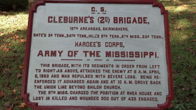
Shiloh is the 15th Arkansas' first battle. The 15th Arkansas formed the skirmish line in the opening attack on Sherman's troops, pushing them in the direction of Shiloh Church. Brigidier General Patrick Cleburne's battle report says, "[t]he Fifteenth Arkansas engaged the enemy's skirmishers and drove them in on their first line of battle. My skirmishers then fell back on their reserve [on their left]. On the map, look for Cleburne's line south of Shiloh Church. Notice the sign puts the 15th Arkansas Skirmishers are in front of the rest of the troops.
 By noon, Cleburne's troops had moved forward to this location. On the map, this location is just to the right of Sherman's name or half-a-mile north of the name Marsh. In one of these places, Cleburne's battle report says, "Here the Fifteenth Arkansas inflicted heavy loss upon the enemy, and lost many good men, and its major, J. T. Harris. He scorned to pay any regard to his personal safety; he moved up within pistol range of the enemy, and was shot dead while firing on them with his revolver." Then later the report says, " Here Captain Cowley, acting major of the Fifteenth Arkansas, a true and tried officer, was shot in the head...."
 At 2:30 pm, the troops moved one-quarter mile, northeast of previous sign. Tilghman Creek is the little vertical blue squiggly line near the top of the map just to the right of the Brewer and Wharton lines and further south near Russell and Wood. I don't know where the 15th Arkansas actually was on Tilghman Creek. East of Tilghman Creek is as far forward as the Confederates would get on April 6, 1862. Union army held this position through the night.

This is Cleburne's final position the next day, April 7, 1862. On this map, the 15th Arkansas is not shown, but this sign is located in front of Gibson, about where the 1st Arkansas and 13th Louisiana are shown. Cleburne's battle report says, "As far as I know the Fifteenth Arkansas was the only regiment rallied anywhere near the scene of disaster. In the face of a deadly fire and an exultant foe the regiment reformed near two abandoned cannons and fell back in order behind a ridge. From this point, seeing some re-enforcements coming up, I led them in a charge on the advancing foe. The enemy fled back faster than they came." "In this charge Lieutenant-Colonel Patton, the sole remaining field officer of the Fifteenth Arkansas, was shot dead. He did his duty nobly in this battle and secured the love and confidence of every man in his regiment. The Fifteenth Arkansas continued to pursue the enemy until out of ammunition, when 58 men, all that were still together, fell back to replenish."
Cleburne's battle report summarized his brigade's performance during Shiloh, "This was the first battle my men were ever engaged in. They led the advance of our army on Shiloh and engaged and repulsed the enemy's cavalry the Friday before the battle. They fought in the foremost line both days and were never rested or relieved for a moment. They captured many stands of colors and assisted in the capture of General Prentiss' Federal brigade on the left."
After Shiloh, the Confederate Army was reorganized. The 13th and 15th Arkansas depleted regiments were combined. As regiments were depleted the Confederate army combined units together rather than adding fresh recruits to rebuild the strength of old regiments.
The 13th/15th Arkansas next participated in the campaign to encourage Kentucky to join the Confederacy. They fought in Battle of Richmond, August 29-30, 1862, (See map.) and Battle of Perryville, October 8, 1862.
When I was a Boy Scout in Kentucky, we commemorated Perryville with a 20 mile hike. Since both sides were trying to get water, I believe we couldn't drink during the hike. Or maybe I am making that up. I also remember memorizing Gettysburg Address during the hike. I believe we repeated it as a group at the end of the hike.
Animated story of the Battle of Perryville.
To see the movements of the 13th/15th Arkansas during the battle, look for Cleburne the far right side of the map. The 13th/15th is shown in front line of Cleburne's. This is the position from noon to 2 pm.
At 2pm, Cleburne moved forward to the dark red line. The 13th/15th Arkansas moved across "Doctors Fork".
By 4 pm, the "13th/15th AR" was able to move forward again to the brown line.
Though the Confederates won the Battles of Richmond and Perryville, the Confederates lost the strategic situation and withdrew from Kentucky. Saving Kentucky for the Union.
Helen Keller, born 1880, turned blind and deaf by an early childhood fever, proved that blind and deaf people could live productive lives if given the opportunity. Keller is the first person to receive a BA degree. Helen's opportunity came by being born in a blue-blooded, wealthy family. According to the house guide, Helen Keller is a descendent of John Quincy Adams.
Keller's family could afford to hire Anne Sullivan to tutor Helen from age 7 through college. Sullivan remained Helen's lifelong associate until Sullivan died in 1936 with Keller holding her hand.
.JPG)
Also outside is the little house Anne asked to be built to create a better situation for teaching Helen.
Many know through The Miracle Worker, Helen Keller's amazing education. Lion's Clubs often speak of Keller's 1925 challenge to become knights for the blind. Few know Keller was a socialist. She campaign for Eugene V. Debs to become president.The house tour guide did not know Keller was a socialist and couldn't imagine how this is possible because Keller had been active in so many charitable causes. Such ignorance of Americans about the left.
The drive from Tuscumbia, Alabama to Shiloh battleground in Tennessee is about an hour. Some distance from Tuscumbia, we passed a sign for the Key Underwood Coon Dog Memorial Graveyard. (YouTube video)
Kathy's great-great grandfather, Samuel Woods Reid, served in Napolean Gray's, Company D in the 15th Arkansas Regiment. (History as the 1st Arkansas Volunteers) This regiment was commanded by Brigadier General Patrick R. Cleburne. Cleburne earned the title, "Stonewall of the West". Ironically, lists of the greatest generals of the Civil War often list Cleburne above "Stonewall" Jackson, e.g., 1, 2, 3. Biographies of Cleburne often say hee is the most forgotten or underrated general of the war.
(Confederate Order of Battle at Shiloh)
Shiloh battlefield is covered with signs identifying the locations of regiments through the battle. Kathy and I photographed the five signs mentioning the 15th Arkansas. Descriptions below identify the locations of these signs on this map.

Scott Manning explains a demonstration a Confederate skirmish line. Skirmishers formed "rows of checkered board patterned troops on one knee. A row would move forward, kneel, and shoot. Then another row would move forward and do the same while the previous row reloaded. They explained that skirmishers would move like this toward a possible enemy position to probe their exact position."

Shiloh is the 15th Arkansas' first battle. The 15th Arkansas formed the skirmish line in the opening attack on Sherman's troops, pushing them in the direction of Shiloh Church. Brigidier General Patrick Cleburne's battle report says, "[t]he Fifteenth Arkansas engaged the enemy's skirmishers and drove them in on their first line of battle. My skirmishers then fell back on their reserve [on their left]. On the map, look for Cleburne's line south of Shiloh Church. Notice the sign puts the 15th Arkansas Skirmishers are in front of the rest of the troops.
 By noon, Cleburne's troops had moved forward to this location. On the map, this location is just to the right of Sherman's name or half-a-mile north of the name Marsh. In one of these places, Cleburne's battle report says, "Here the Fifteenth Arkansas inflicted heavy loss upon the enemy, and lost many good men, and its major, J. T. Harris. He scorned to pay any regard to his personal safety; he moved up within pistol range of the enemy, and was shot dead while firing on them with his revolver." Then later the report says, " Here Captain Cowley, acting major of the Fifteenth Arkansas, a true and tried officer, was shot in the head...."
  At 2:30 pm, the troops moved one-quarter mile, northeast of previous sign. Tilghman Creek is the little vertical blue squiggly line near the top of the map just to the right of the Brewer and Wharton lines and further south near Russell and Wood. I don't know where the 15th Arkansas actually was on Tilghman Creek. East of Tilghman Creek is as far forward as the Confederates would get on April 6, 1862. Union army held this position through the night.
The next morning Union supported by Buell's reinforcements the Federals attacked. See this map of the second day's battle.

This is Cleburne's final position the next day, April 7, 1862. On this map, the 15th Arkansas is not shown, but this sign is located in front of Gibson, about where the 1st Arkansas and 13th Louisiana are shown. Cleburne's battle report says, "As far as I know the Fifteenth Arkansas was the only regiment rallied anywhere near the scene of disaster. In the face of a deadly fire and an exultant foe the regiment reformed near two abandoned cannons and fell back in order behind a ridge. From this point, seeing some re-enforcements coming up, I led them in a charge on the advancing foe. The enemy fled back faster than they came." "In this charge Lieutenant-Colonel Patton, the sole remaining field officer of the Fifteenth Arkansas, was shot dead. He did his duty nobly in this battle and secured the love and confidence of every man in his regiment. The Fifteenth Arkansas continued to pursue the enemy until out of ammunition, when 58 men, all that were still together, fell back to replenish."
Cleburne's battle report summarized his brigade's performance during Shiloh, "This was the first battle my men were ever engaged in. They led the advance of our army on Shiloh and engaged and repulsed the enemy's cavalry the Friday before the battle. They fought in the foremost line both days and were never rested or relieved for a moment. They captured many stands of colors and assisted in the capture of General Prentiss' Federal brigade on the left."
After Shiloh, the Confederate Army was reorganized. The 13th and 15th Arkansas depleted regiments were combined. As regiments were depleted the Confederate army combined units together rather than adding fresh recruits to rebuild the strength of old regiments.
The 13th/15th Arkansas next participated in the campaign to encourage Kentucky to join the Confederacy. They fought in Battle of Richmond, August 29-30, 1862, (See map.) and Battle of Perryville, October 8, 1862.
When I was a Boy Scout in Kentucky, we commemorated Perryville with a 20 mile hike. Since both sides were trying to get water, I believe we couldn't drink during the hike. Or maybe I am making that up. I also remember memorizing Gettysburg Address during the hike. I believe we repeated it as a group at the end of the hike.
Animated story of the Battle of Perryville.
To see the movements of the 13th/15th Arkansas during the battle, look for Cleburne the far right side of the map. The 13th/15th is shown in front line of Cleburne's. This is the position from noon to 2 pm.
At 2pm, Cleburne moved forward to the dark red line. The 13th/15th Arkansas moved across "Doctors Fork".
By 4 pm, the "13th/15th AR" was able to move forward again to the brown line.
Though the Confederates won the Battles of Richmond and Perryville, the Confederates lost the strategic situation and withdrew from Kentucky. Saving Kentucky for the Union.
Thursday, October 4, 2012
Lookout! Wednesday, October 3, 2012
We decided to go to the Lookout Mountain Battlefield Visitor Center of the Chickamauga & Chattanooga Military Park only. The trip up the mountain switches back and forth. There are houses nearly all the way... I sure don't think commuting up and down the mountain during the winter sounds very fun!
Many of the houses are very nice and quite large. The homes on the edge of the mountain seem to consistently have large decks or are otherwise built out over the drop-off. Although the view of Chattanooga in the valley is phenomenal, I'm not sure I would want to live in many of those homes.
We first visited the Battles for Chattanooga Museum. This store has a 3-D map of several battles around the Chattanooga area, including Lookout Mountain and Missionary Ridge. There is an audio presentation while the lights on the map illustrate the troop locations. This gave us a much better understanding of the situation during the fall of 1863 in the area.
The official Visitor Center is next door and has exhibits that give additional insights and information about the various "players" on both sides of the conflicts. We then walked across to the Point Park and walked the trail. The views of Chattanooga were impressive.
 This trip meant something to me (Kathy) because I have a photograph of my great great grandfather Francis Bryan with other soldiers on Lookout Mountain. He served in the Union Army with other soldiers from Ohio. I don't have the exact unit with me, but we learned soldiers from Ohio were there at the battles and that many soldiers had their photos taken on the Point shown in the photograph on the right after the Battles of Lookout Mountain and Missionary Ridge (November 24 and 25, 1863).
I also need to check my other great great grandfather's papers (Samuel W. Reid) when I get home. I know he was captured that fall and began to suspect that these battles might be where he was. Today we learned that Major General Patrick R. Cleburne's regiment held right flank of Missionary Ridge for the Confederates against 10 times more troops. This regiment included Sam's company, the Napoleon Grays (Fifteenth Regiment of Arkansas Infantry) under the command of Major E. Warfield. According to Cleburne's official report, the 15th Arkansas engaged in heavy fighting all day long around Tunnel Hill and captured one Union battle flag. See map. (Confederate Order of Battle)
The date of Sam's captured in nearby Graysville, Georgia, coincide with the Battle of Missionary Ridge.
I must learn some more about both of these grandfathers and their participation in the same battle, different sides. Later in their lives, their children married in Osage County, Kansas!
The history lesson for the day was over, so we headed west with the intention of visiting the battlefield at Shiloh, Tennessee tomorrow. (Yes, we seem to be steeped in Civil War history on this vacation!) Our new Waze navigation took us the quickest route, which meant we spent time in three states today (Georgia, Tennessee, and Alabama). Tomorrow we will drive through a bit of Mississippi on the way back to Tennessee to the battlefield.
We remembered that we have traveled through part of this area a few years ago and were not able to visit Helen Keller's birthplace in Tuscumbia, Alabama, because it was not open the day we were here. Since out path was going by again, we stopped and will visit the home tomorrow morning, before Shiloh.
Last time we were here we stayed in a private campground, but tonight we are at McFarland Park, part of the city of Florence's city park system. There are large pine trees lining the road and we find the park nice for the overnight stop. Water is on both sides of the campground with herons inhabiting Cypress Creek.
Many of the houses are very nice and quite large. The homes on the edge of the mountain seem to consistently have large decks or are otherwise built out over the drop-off. Although the view of Chattanooga in the valley is phenomenal, I'm not sure I would want to live in many of those homes.
We first visited the Battles for Chattanooga Museum. This store has a 3-D map of several battles around the Chattanooga area, including Lookout Mountain and Missionary Ridge. There is an audio presentation while the lights on the map illustrate the troop locations. This gave us a much better understanding of the situation during the fall of 1863 in the area.
The official Visitor Center is next door and has exhibits that give additional insights and information about the various "players" on both sides of the conflicts. We then walked across to the Point Park and walked the trail. The views of Chattanooga were impressive.

I also need to check my other great great grandfather's papers (Samuel W. Reid) when I get home. I know he was captured that fall and began to suspect that these battles might be where he was. Today we learned that Major General Patrick R. Cleburne's regiment held right flank of Missionary Ridge for the Confederates against 10 times more troops. This regiment included Sam's company, the Napoleon Grays (Fifteenth Regiment of Arkansas Infantry) under the command of Major E. Warfield. According to Cleburne's official report, the 15th Arkansas engaged in heavy fighting all day long around Tunnel Hill and captured one Union battle flag. See map. (Confederate Order of Battle)
The date of Sam's captured in nearby Graysville, Georgia, coincide with the Battle of Missionary Ridge.
I must learn some more about both of these grandfathers and their participation in the same battle, different sides. Later in their lives, their children married in Osage County, Kansas!
The history lesson for the day was over, so we headed west with the intention of visiting the battlefield at Shiloh, Tennessee tomorrow. (Yes, we seem to be steeped in Civil War history on this vacation!) Our new Waze navigation took us the quickest route, which meant we spent time in three states today (Georgia, Tennessee, and Alabama). Tomorrow we will drive through a bit of Mississippi on the way back to Tennessee to the battlefield.
We remembered that we have traveled through part of this area a few years ago and were not able to visit Helen Keller's birthplace in Tuscumbia, Alabama, because it was not open the day we were here. Since out path was going by again, we stopped and will visit the home tomorrow morning, before Shiloh.
Last time we were here we stayed in a private campground, but tonight we are at McFarland Park, part of the city of Florence's city park system. There are large pine trees lining the road and we find the park nice for the overnight stop. Water is on both sides of the campground with herons inhabiting Cypress Creek.
Tuesday, October 2, 2012
October 2, 2012 Through Georgia
We visited the Oliver Hardy Museum in Harlem, Georgia, the birthplace of Hardy, the fat one. Next weekend, October 6, is the Oliver Hardy Festival. 30,000 people are expected.
After his birth in Harlem, Hardy's family moved down the road to Milledgeville to run a hotel. Hardy was fascinated by the entertainers who stayed in the Baldwin Hotel. This sparked his interest in show business. The museum's collection is almost solely hundreds of Laurel and Hardy collectables.
.JPG) Kathy and I road in the back of Oliver and Laurel's automobile. (See picture.)
Kathy and I road in the back of Oliver and Laurel's automobile. (See picture.)
Next, we watched a 30-minute 1932 short called The Music Box. This film won the first academy award for live action short.
The rest of the day was driving across Georgia, around Atlanta to just south of Chattanooga, Tennessee. We are staying in a KOA Kampground.
After his birth in Harlem, Hardy's family moved down the road to Milledgeville to run a hotel. Hardy was fascinated by the entertainers who stayed in the Baldwin Hotel. This sparked his interest in show business. The museum's collection is almost solely hundreds of Laurel and Hardy collectables.
.JPG)
Next, we watched a 30-minute 1932 short called The Music Box. This film won the first academy award for live action short.
The rest of the day was driving across Georgia, around Atlanta to just south of Chattanooga, Tennessee. We are staying in a KOA Kampground.
Monday, October 1, 2012 Manning, South Carolina to Georgia
Kathy and Chris spent the morning and early afternoon driving around Manning, South Carolina. Chris spent the summer of 1973 selling Bibles door-to-door in Manning and Summerton, 10 miles south.
In my memory, the Manning 40-years ago was a little run down. My housemate Jim Wilson and I used to eat breakfast in a cafe where I learned to dislike grits. After breakfast, he would drop me off in the neighborhood I was working at the time. I spent a lot of time in the dilapidated houses of the black ghetto because these people opened their doors to a door-to-door salesman.
So much has changed that for a while I thought I was in the wrong town. Most of the houses I visited have been torn down to be replaced by newer houses, lowcost government apartments for black and white residents, banks, medical facilities, or just empty areas. Between the town and the I-95 exit, is a super-Walmart and many of the chains in other towns across America. In the town, are many new medical facilities, banks, etc.
I have numerous memories of this summer. I will share one. Near the end of the summer, my mother and grandmother picked me up to spend a vacation together in South Carolina. Before leaving town, we did washing in a local laundromat. This building was divided into three equal areas. The right end was the dry cleaning business run by the business owner. The other two areas contained washers and dryers. My mother and I went to the dry cleaning area for some reason, e.g., getting change. At one point, the business owner asked in which room we were washing our clothes. We said the middle room. He said that was good. We then realized this was a segregated laundry. The room on the left end of the building was for blacks. When we revealed this arrangement to my grandmother, she went over and sat in the other laundry for the rest of the time. Yesterday, I couldn't find this laundry.
Kathy and I ate a late lunch in a cafe near where I used to pass my grits to Jim Wilson. The cafe is now a boutique store selling pasta salads and deli meat sandwiches with avocado spread on focaccia bread.
After leaving Manning, we drove into Georgia and camped at the Petersburg Campground at the J. Strom Thurmond Dam and Lake. This is a wonderful campground because the campsites are large, well-designed and well-separated from each other. Each campsite contains a fire-ring, grill, food preparation table near grill, a lantern hanger, and picnic table. The restrooms are clean and nice. Finally, few people are here.
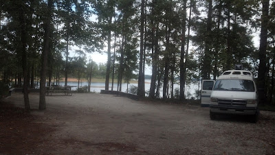
 Our campsite is beside the lake. 200 yards from shore is small island with a flock of geese who honk periodically.
In my memory, the Manning 40-years ago was a little run down. My housemate Jim Wilson and I used to eat breakfast in a cafe where I learned to dislike grits. After breakfast, he would drop me off in the neighborhood I was working at the time. I spent a lot of time in the dilapidated houses of the black ghetto because these people opened their doors to a door-to-door salesman.
So much has changed that for a while I thought I was in the wrong town. Most of the houses I visited have been torn down to be replaced by newer houses, lowcost government apartments for black and white residents, banks, medical facilities, or just empty areas. Between the town and the I-95 exit, is a super-Walmart and many of the chains in other towns across America. In the town, are many new medical facilities, banks, etc.
I have numerous memories of this summer. I will share one. Near the end of the summer, my mother and grandmother picked me up to spend a vacation together in South Carolina. Before leaving town, we did washing in a local laundromat. This building was divided into three equal areas. The right end was the dry cleaning business run by the business owner. The other two areas contained washers and dryers. My mother and I went to the dry cleaning area for some reason, e.g., getting change. At one point, the business owner asked in which room we were washing our clothes. We said the middle room. He said that was good. We then realized this was a segregated laundry. The room on the left end of the building was for blacks. When we revealed this arrangement to my grandmother, she went over and sat in the other laundry for the rest of the time. Yesterday, I couldn't find this laundry.
Kathy and I ate a late lunch in a cafe near where I used to pass my grits to Jim Wilson. The cafe is now a boutique store selling pasta salads and deli meat sandwiches with avocado spread on focaccia bread.
After leaving Manning, we drove into Georgia and camped at the Petersburg Campground at the J. Strom Thurmond Dam and Lake. This is a wonderful campground because the campsites are large, well-designed and well-separated from each other. Each campsite contains a fire-ring, grill, food preparation table near grill, a lantern hanger, and picnic table. The restrooms are clean and nice. Finally, few people are here.

 Our campsite is beside the lake. 200 yards from shore is small island with a flock of geese who honk periodically.
Monday, October 1, 2012
Wash and Waze... Sunday, September 30, 2012
Today was more for getting ready for the next week of vacation than anything else.
The KOA served free waffles for breakfast, so I took advantage of that, while Chris finished off some of the leftovers from our sojourn in the Raleigh, North Carolina, area.
We then decided it was a good time to do our laundry there at the campground. These clean clothes will see us through to the end of this year's vacation.
The afternoon was then devoted to heading south into South Carolina. This is another new state for our map on the side of the camper. (We mark the states we have gone to IN THE CAMPER VAN; not in other ways or times). We know only have Georgia, Michigan, Idaho, Washington, Oregon, Alaska, and Hawaii left in the U.S. We'll get Georgia this week; odds are we'll never take the camper van to Hawaii. So we've visited most of the states since we purchased the camper a few years ago! We've also visited Manitoba and Saskatchewan, so we still have some Canadian provinces to go.
We ate lunch at Zachary's Pizza & Restaurant in Saint Pauls, North Carolina. The Veggie was very good.
A visit to the South Carolina Welcome Center on I-95 was the main high point of the late afternoon. We picked up some tourist materials, including some information about campgrounds. We decided to check out Poinsett State Park. That's where we decided to stay; the sites are really nice and roomy.
Tomorrow's plans include visiting Manning, South Carolina, just a few miles away. When Chris was in college, he actually sold Bibles in this area one summer! Manning is where he lived, and I'd like to see a little of his past.
While driving past on the way to the campground, Chris says it looks like it may be quite a bit larger than it was in the late 1970s. I'm not at all surprised; when I attended high school in Wellsville, Kansas, in the late 1960s, nearby Gardner, Kansas, was still a pretty small town nearby. Now Gardner is growing constantly and seems to be almost an extension of the greater Kansas City metro area!
During the day, I added a new app on my Android called Waze. Waze serves as a navigator program, but also has a social aspect. Users report problems like heavy traffic, accidents, cars parked on the shoulder, etc., which Waze can use to suggest alternate, faster routes for commuters, etc.
It's been fun learning to use the functions included today, and tonight we actually used the Waze site on the laptop to edit the South Carolina map! If you travel on a road that is not marked in Waze, you can mark it as "Paved". Then you can go in on the computer and actually add that road and more information to the Waze maps and database!
There's definitely a learning curve for the editing, but I think I'm getting better. The roads leading to our campsite were not shown correctly; I think they are better now.
I also discovered that Waze's map editor works best with Chrome, so downloaded that browser too!
The KOA served free waffles for breakfast, so I took advantage of that, while Chris finished off some of the leftovers from our sojourn in the Raleigh, North Carolina, area.
We then decided it was a good time to do our laundry there at the campground. These clean clothes will see us through to the end of this year's vacation.
The afternoon was then devoted to heading south into South Carolina. This is another new state for our map on the side of the camper. (We mark the states we have gone to IN THE CAMPER VAN; not in other ways or times). We know only have Georgia, Michigan, Idaho, Washington, Oregon, Alaska, and Hawaii left in the U.S. We'll get Georgia this week; odds are we'll never take the camper van to Hawaii. So we've visited most of the states since we purchased the camper a few years ago! We've also visited Manitoba and Saskatchewan, so we still have some Canadian provinces to go.
We ate lunch at Zachary's Pizza & Restaurant in Saint Pauls, North Carolina. The Veggie was very good.
A visit to the South Carolina Welcome Center on I-95 was the main high point of the late afternoon. We picked up some tourist materials, including some information about campgrounds. We decided to check out Poinsett State Park. That's where we decided to stay; the sites are really nice and roomy.
Tomorrow's plans include visiting Manning, South Carolina, just a few miles away. When Chris was in college, he actually sold Bibles in this area one summer! Manning is where he lived, and I'd like to see a little of his past.
While driving past on the way to the campground, Chris says it looks like it may be quite a bit larger than it was in the late 1970s. I'm not at all surprised; when I attended high school in Wellsville, Kansas, in the late 1960s, nearby Gardner, Kansas, was still a pretty small town nearby. Now Gardner is growing constantly and seems to be almost an extension of the greater Kansas City metro area!
During the day, I added a new app on my Android called Waze. Waze serves as a navigator program, but also has a social aspect. Users report problems like heavy traffic, accidents, cars parked on the shoulder, etc., which Waze can use to suggest alternate, faster routes for commuters, etc.
It's been fun learning to use the functions included today, and tonight we actually used the Waze site on the laptop to edit the South Carolina map! If you travel on a road that is not marked in Waze, you can mark it as "Paved". Then you can go in on the computer and actually add that road and more information to the Waze maps and database!
There's definitely a learning curve for the editing, but I think I'm getting better. The roads leading to our campsite were not shown correctly; I think they are better now.
I also discovered that Waze's map editor works best with Chrome, so downloaded that browser too!
Wednesday, September 26, 2012
Wednesday, September 26, 2012 Raleigh, North Carolina
Today, Kathy and I hung around the campground until 1:30 pm. We then drove toward Raleigh, North Carolina to the Sheraton Hotel and Conference Center, downtown on Salisbury Street.
We are here to attend the annual conference for Association of Rural and Small Libraries.
 After cleaning up, Kathy and I walked 5 blocks north to the old capitol building for a little party. Among the delicacies were homemade potato chips which Gail told us is a common local food. Kathy is intrigued with an upcoming event called "Shuckin' & Shaggin' at the Capitol". Searching Google shows lots of shuckin' and shaggin' on the east coast. I believe the phrase refers to shucking oysters and dancing the Carolina shag. The link goes to a Wikipedia article. Below the article is a link to a two-minute video of a couple shag dancing. Shag Dancing is a type of swing. The Carolina Shag is the state dance of South Carolina.
Gail Santy eventually showed up at the party. We walked back with her talking about library work, food and travel. On the way back we passed a Lebanese restaurant called the Mecca. After this conference, Gail and her family are going to Chincoteague Island as well. We told her about Wallops Flight Facility visitor center.
When we walked into the hotel we met Sharon Sturgis and Harry Willems just finishing dinner in a hotel restaurant.
We are here to attend the annual conference for Association of Rural and Small Libraries.
 After cleaning up, Kathy and I walked 5 blocks north to the old capitol building for a little party. Among the delicacies were homemade potato chips which Gail told us is a common local food. Kathy is intrigued with an upcoming event called "Shuckin' & Shaggin' at the Capitol". Searching Google shows lots of shuckin' and shaggin' on the east coast. I believe the phrase refers to shucking oysters and dancing the Carolina shag. The link goes to a Wikipedia article. Below the article is a link to a two-minute video of a couple shag dancing. Shag Dancing is a type of swing. The Carolina Shag is the state dance of South Carolina.
Gail Santy eventually showed up at the party. We walked back with her talking about library work, food and travel. On the way back we passed a Lebanese restaurant called the Mecca. After this conference, Gail and her family are going to Chincoteague Island as well. We told her about Wallops Flight Facility visitor center.
When we walked into the hotel we met Sharon Sturgis and Harry Willems just finishing dinner in a hotel restaurant.
Tuesday, September 25, 2012
Tuesday September 25, Kitty Hawk
Today Kathy and I visited the Wright Brothers National Memorial at Kitty Hawk. It is full of great exhibits and some fun sculptures to play around with. The monument on the hill, pictured in the Wikipedia article, is the least interesting thing at the memorial.
There is a museum and a centennial pavilion. Both are worth visiting. The displays do a good job explaining the scientific tasks the brothers had to accomplish to fly. We point they make is that the brothers had to act as scientists, not just inventors. They conducted a series of experiments to discover the shape of wing with the greatest lift and least drag. They invented the wind tunnel for these experiments. We should also recognize that they had to invent not only the wings and the propeller, they also had to invent the engine light enough and with enough horsepower because no engine manufacturers would supply an engine that would meet their specifications for lightness and horsepower.
 Outside the museum, the hangers and living quarters are reconstructed. Beside these is the reconstructed track used for take off. Stones mark the distances of their first four flights:
In the pavilion is video showing 2003 attempts at flying reconstructed Wright Flyers. These pilots did less well. One flight was only 97 feet.
On the other side of the Kill Devil Hills monument is a life-sized sculpture of the first flight. People can get up on the sculpture to have their picture taken. Fun.
There is a museum and a centennial pavilion. Both are worth visiting. The displays do a good job explaining the scientific tasks the brothers had to accomplish to fly. We point they make is that the brothers had to act as scientists, not just inventors. They conducted a series of experiments to discover the shape of wing with the greatest lift and least drag. They invented the wind tunnel for these experiments. We should also recognize that they had to invent not only the wings and the propeller, they also had to invent the engine light enough and with enough horsepower because no engine manufacturers would supply an engine that would meet their specifications for lightness and horsepower.
.JPG) |
| Chris holds on for dear life during the first flight. |
 Outside the museum, the hangers and living quarters are reconstructed. Beside these is the reconstructed track used for take off. Stones mark the distances of their first four flights:
- 120 feet in 12 seconds (6.8 mph).
- 175 feet in 12 seconds. (9.8 mph)
- 200 feet in 15 seconds. (9 mph)
- 852 feet in 59 seconds. (9.8 mph)
In the pavilion is video showing 2003 attempts at flying reconstructed Wright Flyers. These pilots did less well. One flight was only 97 feet.
On the other side of the Kill Devil Hills monument is a life-sized sculpture of the first flight. People can get up on the sculpture to have their picture taken. Fun.
Monday, September 24, 2012
Monday, September 24, 2012 - From Space to Kitty Hawk
Today, we drove from Chincoteague Island on Virginia's Eastern Shore to Bodie Island on the Outer Banks in North Carolina.
Very soon after leaving camp on Chincoteague Island stopped at the NASA Wallops Flight Facility, a part of the Goddard Space Flight Center based in Maryland.
Wallops specializes in suborbital flights with high-flying balloons (20 annually), rockets (25 annually), and high flying airplanes. The balloons are composed of 0.8 mil polyethylene film, i.e., thickness of a sandwich bag, and taller that the Washington monument. They can carry 8,000 lbs. loads to 120,000 feet, i.e., 22.7 miles, and even higher with lighter payloads. They can rise above 99.5% of the atmosphere to even study space. Rockets carry equipment weighing up to 1,200 lbs. from 30 to 800 miles up. Their research includes measuring changes in the ice sheets over the north and south poles, changes in the land and sea temperatures, plant life, the sun and other planets, and testing instruments for use on such flights.
The coolest thing in the visitor center is a large globe that is a screen for projecting movies, called Science on a Sphere. Kathy and I saw a short film about Jupiter. Jupiter's surface on the sphere while a voice describes its features. (YouTube version slightly different) Actually, four projectors project the same film on four sides of the globe. Since you are sitting on one of the four sides watching only one of the projections, this gives the impression that the whole planet is being projected onto the sphere. It was very neat.
As we drove south down highway 13, etc. to the North Carolina Outer Banks, our hearts were warmed by all the "Eastern Shore for Obama" signs.
The Outer Banks are so built up and overcrowded I can't see why anyone would stay here any more. Tomorrow, I want to see the Wright Brothers National Memorial at Kitty Hawk and leave.
Addition by Kathy: Wallops also has the distinction of being the facility that sent the first female into space. This was a rhesus monkey name Miss Sam in the early days of the space program! You can also read more about the future of the Wallops Facility in this Washington Post article.
Very soon after leaving camp on Chincoteague Island stopped at the NASA Wallops Flight Facility, a part of the Goddard Space Flight Center based in Maryland.
Wallops specializes in suborbital flights with high-flying balloons (20 annually), rockets (25 annually), and high flying airplanes. The balloons are composed of 0.8 mil polyethylene film, i.e., thickness of a sandwich bag, and taller that the Washington monument. They can carry 8,000 lbs. loads to 120,000 feet, i.e., 22.7 miles, and even higher with lighter payloads. They can rise above 99.5% of the atmosphere to even study space. Rockets carry equipment weighing up to 1,200 lbs. from 30 to 800 miles up. Their research includes measuring changes in the ice sheets over the north and south poles, changes in the land and sea temperatures, plant life, the sun and other planets, and testing instruments for use on such flights.
The coolest thing in the visitor center is a large globe that is a screen for projecting movies, called Science on a Sphere. Kathy and I saw a short film about Jupiter. Jupiter's surface on the sphere while a voice describes its features. (YouTube version slightly different) Actually, four projectors project the same film on four sides of the globe. Since you are sitting on one of the four sides watching only one of the projections, this gives the impression that the whole planet is being projected onto the sphere. It was very neat.
As we drove south down highway 13, etc. to the North Carolina Outer Banks, our hearts were warmed by all the "Eastern Shore for Obama" signs.
The Outer Banks are so built up and overcrowded I can't see why anyone would stay here any more. Tomorrow, I want to see the Wright Brothers National Memorial at Kitty Hawk and leave.
Addition by Kathy: Wallops also has the distinction of being the facility that sent the first female into space. This was a rhesus monkey name Miss Sam in the early days of the space program! You can also read more about the future of the Wallops Facility in this Washington Post article.
Subscribe to:
Posts (Atom)

