Friday, August 29, 2008

Monday, August 25, 2008, Canyon De Chelly

At 8 this morning, we ate breakfast at the Thunderbird Cafeteria (review). (Reviews of Thunderbird Lodge) Kathy had French toast, undercooked hash browns and juice. Chris ate two sausage patties, corned beef hash, chipped beef gravy on two biscuits and a bottle of milk. On the walls was a nice selection of Navajo rugs for sale. Chris thought the patterns were not genuine Navajo patterns. On the walls of a back dining room near the restroom was an assortment of Indian quivers with arrows for sale. They looked less fake to Chris' keen, untrained eye.

We purchased a tour of Canyon De Chelly from a store next to the cafeteria. Right before 9 am, we climbed into the back of a six-wheeled army-type truck for a tour of Canyon De Chelly. Tourists are not allowed in the canyon without guides. Without guides tourists can only view the canyon from overlooks on the canyon rim.


Our Navajo guide and driver, Ray, I believe, described the tour's itinerary. Indians laugh and joke more than Anglos. A lot of their humor is teasing. In Ray's warning about losing stuff he claimed lots of Navajo are getting rich finding stuff fallen out of guide trucks. After this speech and every speech, Ray got into the truck cab and drove us to the next spot. We could not talk with him during the trip.

Canyon De Chelly is a box canyon. It is not created by a river running through it. Rather when it rains water from the higher ground pours into the canyon, carrying rock down the wash and out the mouth of the canyon toward the town of Chinle, which means “place where the water flows out."

Ray entered the canyon driving up a wide wash of deep sand. He had to use four-wheel drive through the whole tour. Ray did not drive “down” into the canyon. Instead, the canyon rose up around us. The walls are 1,000 feet high at the canyon's end.

In the old days the canyon floor was covered in sand right up to the canyon walls. There were no trees. Now the canyon floor is lined with cottonwoods, Russian olive and tamarisk trees, meadows, and farmland with the wash running down the middle. (The Russian olive is not native to the canyon. The Navajo are cutting out the Russian olive to raise the ground water level. Like what the Africans are doing in their dry areas.)

As we moved deeper in the canyon, the canyon became wider, the trees, meadows and farmland started filling the canyon floor and the wash became narrower, wiggling back and forth along the canyon floor. Ray started driving straighter short cuts through the woods instead of following the wiggling wash.The ride became increasingly jarring, much worse than riding rapids in an inflated raft. Several Indian vendors asked us, with knowing smiles, how the trip was. It was that friendly Navajo teasing again.

At each stop Ray would get out of the truck, stand on truck step facing us and tell us about the site. Every stop, except the two rest stops, were “ancient puebloans” petroglyphs or cliff houses. “Ancient puebloans" is the new name for the Anasazi.

The Hopi, who live in pueblos, claim the Anasazi or “ancestral puebloans” are their ancestors. So the Navajo guide, Ray, was telling us about the archaeological remains of ancestors of a competing group, the Hopi. On the second stop, the first cliff house, Ray told us that Navajos were taught from childhood not to go near the “ancestral puebloans” cliff houses. The spirits of the ancestral puebloans living in the ruins will make Navajo sick.

At the two rest stops, there were vendor booths selling mostly Navajo jewelry, one sold flutes and one or two sold pottery. The quality seemed quite high and the prices reasonable, ranging from as low as $5 to $350. Kathy purchased one many-strand necklace and took the business card from another vendor.

Twice Ray told us that his relatives were Navajo rug makers. According to him they often made little rugs, I think about the size of place mats. They sold for $50 to $75, compared to full sized rugs that went for hundreds of dollars.

We saw lots of horses in the canyon, behind fences and wandering free. Ray told us several horse stories. He told us about well trained Navajo horses that will forget about the rider on its back and run down deer in a fifteen mile chase. When the deer is down, exhausted, Navajo hunters dismount and blow corn dust up the deer's nose to suffocate the animal. The skins of these deer are used in a special ceremony because their skins are not pierced with arrows or spears. He then asked who wants to go hunting tomorrow.

In another story, an Anglo woman from Oregon, I believe, wanted to release one of her old horses in the canyon to roam free. Ray had advised her against this because someone would take the horse as their own.

At one stop, Ray pointed to white streaks on huge boulders near the canyon walls. The white streaks are “surfing” marks made by children sitting on flat rocks and sliding down the boulders.

Ray, then, drove the truck a short distance around a canyon corner to a perpendicular cliff about 500 feet high. A trail of hand and foot holds lead almost straight up the canyon wall. Many canyon residents have second dwellings up on the rim. Parents send their kids into the canyon to pick some vegetables or fruits from their canyon gardens and fields. They use these holds to go up and down the canyon walls. I think Ray said there were over a hundred of these trails.

At 1:30 our tour ended near a wonderful cactus bush.

Kathy asked the guide whether the land we saw in the canyon was “legally” or just “traditionally” owned by families. Ray said the fenced in land was “legally” owned by families. The non-fenced in land was traditionally owned by families. On the tour, Ray told us that some families own several plots of land. The families will inhabit different plots of land at different times of the year depending on the crop they are growing at that time. Ray also told us that many of the canyon dwellers work at regular jobs during the week and return on weekends to tend their canyon crops.

From Canyon De Chelly we drove east listening to the Tony Hillerman abridged audiobook, Hunting Badger. Navigator Kathy was pointing on our road map the places mentioned in Hillerman's book. Many of the places are nearby.

We stopped at a large Diné supermarket." Diné” means “the people” in the Navajo language. In other words, we stopped at a Navajo supermarket looking for Indian food. This supermarket was little different from large Dillons store. Though better stocked than our Great Bend “big” Dillons, the biggest difference is a greater selection of mutton and lamb. We were disappointed that we didn't find some new and interesting foods to try. We purchased junk food and drove away continuing the story of Hunting Badger.

We stopped for the night at Bluewater Lake State Park in the Zuni Mountains just east of the Continental Divide. It is a nice campground though the women's facilities need better maintenance.

I observed that starlings had stuck one mud nest on the ceiling of the bathroom porch. A starling would fly around as visitors approaching the bathroom, but at a distance that was little noticeable because the strong wind kept blowing the bird far down wind and then the bird had to fly back up. On porch I heard chirping sounds from the mud nest. I thought it may be babies, but, eventually, a beak appeared and an adult flew out to join its mate.

The next morning as I carried trash to the trash bin, I saw a ground wasp come out of a hole and stand around flickering its wings. I could see a worm laying in the hole. I supposed the wasp had stung the worm into immobility and had laid eggs in the worm. I was puzzled why the wasp left the hole open. I would have thought that the wasp would cover the hole to prevent other animals from finding and eating the worm and the wasp's eggs.

Thursday, August 28, 2008

Sunday, August 24-Visiting Sovereign Nations

Sunday morning, our travelers first returned to the Movie Set Museum. The owner had suggested we return in the daylight when we first met him the night before.

The “museum” part of the Trading Post is out back and is a rather eclectic combination of actual movie-related buildings and props and old-time items. It seems that some of those old-time props have also been later used in movies!

The principal items to be viewed were from the Clint Eastwood film, The Outlaw Josey Wales. There are several others, too, but some of the more recent structures were for a Kenny Loggins music video and then a recent film now called The Attic Door (we hadn't heard of it).


We left (and yes, to those keeping track, we do tend to jump back and forth between first and third person! Thanks heavens we aren't being graded for this; and no college students will be plagiarizing if they want a good grade!) Kanab and headed back into Grand Staircase-Escalante National Monument. We crossed the border at Page, Arizona. This town is at the southern end of Lake Powell/Glen Canyon National Recreation Area.

The rest of the day was spent driving across Native American territory. Of course, the largest reservation in the Four Corners area is that of the Navajo Nation. We followed Highway 89 south and turned east toward Tuba City. From there we drove Hwy. 264 across the Hopi Indian Reservation, turned north on 191 and ended up at Chinle, Arizona for the night. More about that later.

We discovered that Tuba City is on the north side of the highway, and a community called Moenkopi is on the south side. Tuba City is Navajo and the south side is Hopi. There is a large truck stop at the corner where we turned. Because we were looking for information about upcoming possible campsites, we stopped in.

While checking out the variety of businesses (the whole establishment is larger than Shannon's Petro 2; it has the truck stop, a fast-food restaurant, and three small craft shops), we began talking to the owner of one of the small shops. His name is James Surveyer and he shared much history and lore with us about the Hopi and the Navajo. He is a member of the Hopi tribe.

Contrary to some tribes that allow members who have smaller amounts of the tribe's “blood”, the Hopi only allow tribal members if they are full-blood or half-blood. Despite the fact that James is a business owner, he said the Navajo are more entrepreneurial and the Hopi place more importance in their relationship with the land and maintaining that important link.
We enjoyed our conversation with James and wish him well with his shop. We also ended up purchasing several items from him!

There were not really any campgrounds on the rest of our route. Even the campground at Canyon de Chelly at Chinle didn't have electricity for our C-Paps. We decided to splurge and stay there at Canyon de Chelly (a National Monument) at the Thunderbird Lodge.

They sell Tony Hillerman audiobooks and also some used books and tapes in the lobby of the office there. We purchased a used tape of Hillerman's Hunting Badger to listen to the next few days while we were in “Hillerman Country”. Anyone who reads Hillerman's books has probably already recognized the Tuba City references. It has been fun listening to this while we drive; we've gone through other oft-mentioned communities like Chinle, Window Rock, and Gallup. It's fun to picture the action better after driving through Utah and Arizona for the last week.

When we approached Chinle, there were bright lights shining in the sky. We discovered that it was the Central Navajo Fair, including an annual rodeo, carnival, and traditional dances. After checking in to the Lodge, we returned to attend the Fair. Unfortunately, it was just ending. We walked around and watched the carnival folk begin tearing down their booths and that was interesting. One vendor was also having a sale on left-over corn dogs, so Chris bought one.

Tomorrow's plans are to tour the Canyon somehow. Then we will begin a leisurely drive toward Roswell, New Mexico, before returning to Kansas.


The End...

Saturday, August 23, 2008, To Zion

On the way to Zion National Park we passed through Virgin, Utah. There are two tourist traps in this wide spot in the road. We were trapped by the one with the whimsical western town out front called "The Virgin Trading Post".


Inside was a mixture of quality and junk goods. Chris was attracted to their extensive line of hot sauces with funny names like “Colon Cleaner”.

Kathy by the Indian crafts and t-shirts. When looking at Indian crafts Kathy is thinking of a present for Shawn, who thinks he may have Cherokee blood. Unfortunately, despite the Trail of Tears, Kathy's problem is that North Carolina is the best place for Cherokee crafts. In fact, the Indian “junk” labeled Cherokee (and this particular stuff is junk) is made in North Carolina. The good Indian stuff worthy to be called “craft” is Navajo or Hopi.

One t-shirt we have seen in several different forms has a photo of either a line of mounted Plains Indian warriors (probably from the movies) or real Apache warriors standing with rifles at the ready. Below the picture are the words, “Homeland security - Fighting terrorism since 1492.” Chris preferred the t-shirt with a picture of Michelangelo's Sistine Chapel God with extended finger. Above him a word bubble says, “Pull my finger.” Below is the label, “The Big Bang Theory of the Universe.” Austin would think this t-shirt is hilarious if he knew what the Big Bang Theory of the Universe is.

As Kathy and I were walking to our van with 2 bags of rock candy and a bottle of “Hot Sauce for Sissies” we overheard one newly arrived tourist say to his party, “A Virgin Trading Post, maybe we can swap Charlie for something useful.”

Zion National Park is another canyon park. It is a very crowded park, possibly because it is the furthest west national park in Utah. The hoards of California tourists driving to the Colorado Plateau hit this park first, then Bryce Canyon. Unfortunately, Zion is small. Visitors are required to ride propane-powered shuttle buses into the canyon. The buses stop at numerous bus stops through out the canyon.

During his 2000 trip to the Colorado Plateau Chris had seen a photograph of the bottom of a slot canyon. The slot canyon was about 6 feet wide or less and the striped sandstone walls were very smooth. Chris thought the picture was taken in Zion. Chris wanted to see this canyon. Chris asked at the visitor center were this canyon might be. He was directed to get off the bus at Weeping Rock and hike the Observation Trail to Echo Canyon.

Kathy and Chris got off the bus at Weeping Rock. Together they walked a steep incline to Weeping Rock. The top of the canyon is sandstone which is very porous. Rain on the land above seeps down through the sandstone until it reaches a layer of non-porous shale a couple of hundred feet above the bottom of the canyon floor.. Since the water can not penetrate the shale it leaks out pouring down the canyon walls. Ferns and other plants requiring lots of water establish themselves in the cracks and crevices on the canyon walls, creating a hanging garden. (YouTube video)

Chris left Kathy at the Weeping Rock hanging garden for his trudge up to Echo Canyon 700 to 1,000 feet above. And a trudge it was. The path was very steep, switched back and forth at least a dozen times. Eventually, Chris rested every 30 to 40 steps.

Chris had lots of resting time to mull over his goal of walking to Echo Canyon. Since he wanted to go to the bottom of Echo Canyon, he assumed that when he reach the top of this ridge, he would have to walk just about as far down into the next canyon and, then to return, walk back up. He began to worry that he might run out of insulin in his body (as a diabetic his body no longer makes insulin) and so he would be stuck on the other side of the ridge unable to burn his body fat to get back. So he began thinking that he should turn around at the top of the ridge.

Fortunately, at the top of the ridge, the path was level. Instead of the path dropping to the floor of Echo Canyon, the floor rises up to the path. After walking 100 yards, Chris met a couple walking back. They told Chris that the canyon floor was about 5 minutes ahead. After another 100 yards, Chris could see the canyon floor 100 feet below was the sandstone pattern he wanted to see, but could he get down? Then he heard the voices of ,and saw, three French hikers down there on the canyon floor. In another 100 yards he found an easily traversed slope that lead to the bottom of the canyon. Chris had reached his goal and took pictures.

The hike back was much easier and faster.

Chris saw a cute little snake and a lightening-fast neon blue tailed lizard.


A deer browsing flowers on the hillside dislodged a rock that Chris had to dodge.

When I meet Kathy again, she related her adventures waiting for me. She had found a comfortable spot to read by the stream (well, actually on a rock IN the stream. Her feet in the stream kept things much cooler!) Unfortunately, she was constantly terrorized by some vicious flies. She also asked a young . couple whether they had seen her husband. They confessed that when they had spoken to him he was almost to his goal and was probably by now on his way back.

When Chris and Kathy got back to the car, we drove out the other side of Zion through a mile long tunnel. On the shuttle bus back to the visitor's center, the tourist in front of us told us that big horned sheep were on the other side of the tunnel. So we looked for these sheep. Sure enough we saw one standing on a ridge overlooking the highway. The location and pose was so perfect, that Kathy and Chris wondered aloud whether this was a real, live sheep or a stuffed sheep stuck up there for the tourists. Chris was very tempted to turn around an go back to see whether the sheep was still there in that same spot and pose.

But we drove onto Kanab, Utah (Kuh-nab') for the night. We discovered several things upon arriving at Kanab. A festival of “Western Legends” had just ended that day. The town was full of visitors. We got the last available spot in the Good Sam RV park because someone else had just cancelled.


As we walked about town we discovered through signs that Kanab was a center for shooting western movies and television shows. After eating in a great restaurant called the Rocking V (Reviews) we went over to the free movie set museum and trading post. Like the Virgin trading post, this store had a mixture of good crafts and tourist junk. Since it was dark, we put off viewing the movie set until the next morning.

Sunday, August 24, 2008

Friday, August 22, 2008--Bryce and William

Today's first big adventure was going to Bryce Canyon National Park. Even though Kathy had commented earlier to Chris that one rock was beginning to look like every other rock, it is not strictly true. Bryce Canyon appeals to the whimsical side of us all and is definitely worth seeing.

The two main places we went in the Park were Inspiration Point and Natural Bridge. We could not go elsewhere because they were doing controlled burning in some of the park that day.

Inspiration Point is the truly whimsical site. After climbing to the observation area (huff and puff, huff and puff-kdr), visitors look down into what could be a fairyland of towers. Or they could be the remnants of ancient castles and monuments to kings and queens and remind viewers of something out of Tolkien's Lord of the Rings.


Natural Bridge has been photographed many times and really isn't a natural bridge. It's actually an arch. The difference (Kathy's un-scientific explanation) is that one is formed by water erosion and the other by wind and other forms of erosion. Either way it is an impressive natural wonder.

We then left the national park circuit briefly and spent the rest of the day appealing to Kathy's sense of fun. Before leaving on the vacation, she ran off details of anyone in her genealogy database that had done anything in Utah, Colorado, New Mexico, or Arizona (just in case our route matched the data).

Sure enough, one gentleman that was supposedly the brother of Henry Jones (Ben, Jason, Kyle, and Megan's paternal great great great grandfather) and his several wives were supposed to be buried in either Paragonah (Pair-a-goo'-nah) or Parowan (Pair'-a-wahn), Utah, and those towns were easy to reach from Bryce National Park. So, it was on to the cemeteries to look for William E. Jones and any of his clan!

We first arrived at the small town of Paragonah's cemetery. Luckily, they have a directory and map of the burials there. We easily found the Jones listings and one appeared to be one of Williams' wives (Kathy's record said "Sarah Davies" and the cemetery listed "Sarah Davis Jones".) We found and photographed the stones for Joneses in about four different lots. They seemed that they might also be related. One neat thing is that many families in that cemetery use the back of the stones to list the children of a couple!

On to Parowan, which is a larger community. Even though it was Friday night, the library stays open until 9 PM! Those blog readers who work or have worked in libraries (probably most of our readers!) can appreciate how rare that is. We both started going through the books on the history of the area, especially those recommended by the librarian.

The history of the area basically becomes the Mormon history of the area in most of the works we saw. It was discovered that William E. Jones served as the LDS bishop for Paragonah for quite a few years in the 1800's. And some of the wives listed in Kathy's files (which came from LDS Ancestral Files submissions) were actually plural wives! It seems that he was even one of the leaders that was jailed during that turbulent time.

Well, to make the story end soon, it now appears that William E. is NOT an uncle. The biographical data we found listed about him gives another set of parents. So there is definitely some confusion to sort out here. Of course, he could be some kind of cousin, but those of us that have lived around Lebo, Kansas, realize that Joneses are a dime a dozen when we are talking about the Welsh!

We did go out to the cemetery and, even though there was no directory, we walked the older parts and Chris discovered William's stone. We did photograph it. Even if all these folks are not our kin, we will load the pictures onto Find a Grave if they are not already there.


Headed south on Interstate 15 and spent the night in a KOA in Cedar City. It was time to do laundry, so we were up late doing that. Plans for the next day include going to Zion National Park and then heading for Arizona. Our next possible destination after that is now Canyon de Chelly National Monument in the middle of the Navajo Nation Indian Reservation.

Saturday, August 23, 2008

Thursday, August 21; Double Parking

We spent last night at Dead Horse Point campground. The campground is near the rim of a box canyon. Chris followed the wash from the campsite down to the rim. Though the rim looked close, it took Chris 30 to 40 minutes to get there. It was an interesting, but not spectacular view. On the way back Chris discovered a trail back to the campsite that was marked with short little rock cairns.

In the morning we left Dead Horse Point campground heading south toward Glen Canyon recreational area.

At Glen Canyon Recreation Area, i.e., a big lake (Lake Powell) created by a dam, we stopped at the overload of the now flooded town of Hite, Utah. At the height of the uranium mining, Hite grew to 200 people. After the uranium mining rush, Hite, according to the sign, declined to being a "small-town" again. Kathy was impressed that there was no railing on the cliffs.


We ate brisket sandwiches for lunch in a roadside box canyon.


In another canyon we came across a tale of an Indian fight. One soldier and one blacksmith were killed.


We reached Capitol Reef National Park at about 3 pm. Capitol Reef is a hundred mile long land reef that blocked passage west. Its rock "waterfolds" also capture water and hold water creating an oasis of flowing streams and trees in the desert. The indians were here for hundreds of years as proven by irrigation ditches and petraglyphs.

The Mormons settled this area specializing in fruit orchards.

After leaving Capitol Reef, we drove through part of the Dixie National Forest. ("Finally!" Kathy cries. "A real live mountain forest that has trees!") We saw six deer that day from Capitol Reef through Dixie, including one fawn. One stretch of highway was along a spit (?) and the cliffs went down on both sides of the roadway. Kathy cringed the entire section and urged Chris to watch the road ONLY, even though the view was amazing.

We spent the night in Escalante, Utah for next morning's approach to Bryce Canyon National Park.

Wednesday, August 20- Kathy Goes Swimming

Wednesday morning our intrepid explorers were up earlier than usual and were at the Moab Adventure Center by 8AM for our river rafting trip. We had signed up for it the day before. We had picked a full-day trip that goes fourteen miles down the Colorado River. This was Kathy's first rafting trip, it was Chris' third.

We had figured out how to have everything they had recommended for the trip, although some others definitely didn't. We had bottles of water in special bags we made from lingerie bags (thanks to Dollar General!) and carbiners. We also found a “glasses restrainer” to hold on my glasses (Chris had one for his sunglasses) and bought some nice shoe laces to hold on our straw hats (we already had them). Our guide praised us for our resourcefulness and it all came in handy!

Despite the fact that we had not read Shannon's advice for sitting in the front of the raft, that is where we ended up! I hate to admit it, but I (Kathy) was the oldest on the raft. We were the only raft that had full dayers; the other rafts had AM or PM trips only. In addition to our entertaining and fun guide, Becky (history education major at BYU!), there were six other members of the crew.

Sarah was our international member and hails from Birmingham, England. She's a 19-year-old who is traveling around the States by herself, although she has visited some relatives while here. She still has three weeks to go and then will return to begin college in Leeds studying “New Media”.

Sophie works for a subsidiary of TripAdvisor.com called “Virtual Tourist” and lives in the LA area, I believe. She is ½ Swiss and ½ Persian and didn't emigrate from Switzerland until she was eleven.

The other four were all the family of Michael and Jennifer, and sons Mark and Scott. Michael is head chef for all the restaurants in the Las Vegas MGM Grand! The boys were about 10 and 11. Mark, the eldest, really got into planning attacks on the other rafts!

The morning was fun and fairly relaxing. Chris and I discovered that sitting in the front means becoming wetter than anyone else usually! We lazed around occasionally and anyone that wanted to swim could for a while. Then there were “smile breaks” when someone “swam” and the water got a little warmer in their vicinity!

We stopped for a barbecue lunch at a resort ranch on the river; hot dogs and hamburgers with all the trimmings, three side dishes, chips, and cookies.

Shortly after lunch we started again. We encountered the biggest rapids of the day. And that's when Kathy went swimming! Not by choice....

Everything was going fine. We were paddling away when Becky told us to and stopping when she told us to. The raft was going up and down into large troughs between the waves. I (Kathy) had put both feet back in the raft (I'd been straddling the side with a foot in the water) because I thought it would be safer in the rapids because of rocks.

Well, we went down into one of the troughs and that's about the last thing I remember. I somehow lost my balance and fell overboard! Although I didn't realize it at the time, I guess my arm also hit Sophie behind me and she went overboard too!

Becky later said she thought we both did just what we should do. I was never really scared at all, even though the rapids were jostling us around quite a bit. I even opened my eyes under water like I usually do and looked for the raft. Becky had placed the raft sideways in front of us so it was merely a matter of swimming a few strokes to the raft.

Chris tried to pull me into the raft but I started telling him, “stop, it's choking me!” Actually, my hat was still hanging down my back from the chin tie and that was choking me, not the life jacket. They helped Sophie into the boat, Chris took my hat, and then he and Becky hauled me in. I hate to admit it was not my most graceful moment!

And the funniest thing about it all was that when it was over Becky said, “I can't believe you held on to the paddle the whole time!” I had. I told her that I had always tried to be frugal, so I wasn't going to let a piece of equipment go to waste! Actually it was all just a reflex to hold onto it.

Well, the excitement was over for me somewhat! The rest of the trip included several skirmishes with the other rafts and kayakers in which large amounts of water was either splashed or thrown at the opponents from large buckets. Once again Chris and I received most of that water in the front; from both the other teams and our own!

All in all, we had a good time and shared a day with congenial companions. Sophie and I agreed that it was nice to have a special story to tell about our day, too. Pictures of our rafting trip are included at Moab Action Shots . Our raft is shown in photos 1-5 and 36-39. Look for the boat with people at the front with straw hats (you may recognize us!) Unfortunately, they didn't get Kathy's fall on film...

We returned to Moab around 4 PM and did some errands and got some ice cream. (OK, Kathy got some ice cream!) We then headed out to the campground at Dead Horse Point State Park. We were both pretty bushed. Kathy read a while sitting in the lawn chair and then moved to the camper and read/dozed/read/etc. until she actually “went to bed”.

Chris hiked to the rim of the canyon near the campground and took pictures. He then came back and decided to “take a nap” which turned into a four-hour nap. Then he had trouble going “to bed!”

The campground was nice in a stark sort of way and had electricity. They don't have showers though; all water in that area has to be hauled in. We liked the fact that it wasn't a commercial campground and “real campers” seemed to be the ones using it.

The stars were phenomenal that night! Since we were far from civilization there seemed to be thousands more than usual. It was really neat.

Enough for now. Hope everyone in Kansas (and all our fans worldwide-LOL) is doing well. Now get back to work!

Thursday, August 21, 2008

Dead Horses and Canyons

First thing this morning was a visit the National Park Service headquarters in downtown Moab. Chris told them he wanted a raft trip in which everyone got to paddle. My first rafting trip in the Royal Gorge in Colorado was one in which everyone paddled. On my second trip through Hell's Canyon on the Snake River in Idaho, only the guide paddled and we watched. Paddling is a lot more fun. If I can't paddle, I don't want to go.

A woman at the National Park Service claimed only one rafting company, Western Adventure Center, let people paddle. So we signed on with them for a full day, tomorrow. They told us we needed water bottles, level 50 sunblock, waterproof camera, hats, and if you take glasses, then put of attachments to keep them on. That evening we purchased what we needed at a Family Dollar store and a local pharmacy/general store. I wanted a net bag to keep everything in. Kathy recommended bags used when laundering lingerie. We purchased these at the Family Dollar Store. We used carbiners to attach the bags to our life jackets or the boat.

After registering for the rafting trip, Kathy and I spent the rest of the day visiting Dead Horse Point State Park, Canyonlands National Park and Arches National Park. All are within 20 miles of Moab. The scenery at all three parks are stunning. We also purchased reservations for a camping space at Dead Horse Point State Park.

Dead Horse Point is named after a legend. Back in cowboy days, there was a herd of wild horses the cowboys wanted to capture. The easiest way to do this was to pin them in a place where they could not escape. Dead Horse Point is a spit of land 2,000 feet above the Colorado River. The cowboys chased the herd out onto this point and blocked the narrow neck between the point and the rest of the plateau with a fence of juniper bushes. Legend says that after the cowboys captured the animals they wanted, they left the unwanted horses fenced in. The animals died of thirst standing on a point 2,000 feet above the river.


Standing on Dead Horse Point looking down at the Colorado River 2,000 feet below.

Tuesday, August 19, 2008

Onto the plateau

We left Limon, Colorado this morning at about 10 am. We drove straight through Denver, stopping near Golden, Colorado to visit Buffalo Bill's hilltop grave on top of Lookout Mountain.
When we arrived someone was parasailing at about two to three hundred feet out from where we were standing. Generally, he spiralled down, but at one point he rode the wind up to a hundred feet above us and then spiralled back down. It was very cool to watch. What a great sport!

Someone else's YouTube movie of the grave. In the picture of the right Buffalo Bill's grave is to the left of the star. His wife to the right. The star says that he was a member of the Grand Army of the Republic.

The plaque under the star says he earned the Medal of Honor serving with the Third Cavalry during the Indian Wars.

We ate lunch in a nearby park. We were joined by several friendly bees. As we were finishing, a park truck arrived to pump out the porta-potties, filling the air with the aroma of liquid excrement. It was definitely time to leave.

We drove on to Grand Junction, stopping briefly to make some purchases at a Target. Then onto Moab, Utah, near Canyonlands National Park.

We are staying at the KOA campground. We may be here one or two more days. Tomorrow I will check into river rafting. If we do go on a trip, the trip will be on Wednesday. After checking into river rafting, we will probably visit Canyonlands, Dead Horse Point and/or Arches parks.
Posted by Picasa

Sunday, August 17, 2008

Parking at the Park in Park

It may come as a surprise to those that know and love us, but we didn't get away from Great Bend quite as early as we had planned. So...we'll blame it on Kyle. She came by and we'll say that slowed us down. Actually she helped load some of the clothes and food into the camper.

Ben arrived home from Kansas City and then left for work, so we also got to tell him good-bye again.

Then it was "errand time". Kathy had three things to mail that needed to go out. We went to the library to weigh them, picked up some audiobooks for the trip, and then bought stamps at Dillons.

We left GB about 2:27 PM. The packages were mailed in Hoisington. Ahhhh, finally the trip has "officially" started!

Our first meal was lupper (or is that dupper?), which is our name for the meal between lunch (or dinner) and supper, similar to brunch. We decided to park at the park in Park!!! Park, Kansas, that is. You can see Kathy finishing dessert (a banana, what else?) at the park in Park. That is one large Catholic church for a tiny town! It's rather impressively situated at the end of the street (there is no definite "Main Street" in Park). There's a cemetery behind it too.

Although the sun tried to come out for little while, most of the day has been overcast. Then, between Burlington and Limon, ,Colorado, the rain started. It's obvious that they have been getting a lot of rain because the fields are waterlogged. We have stopped in Limon at the KOA for the night. It's lightly raining still and parts of the campground are actually flooded. The young man at the desk said all the "electric only" sites are under water, so he gave us an electric/water site for the electric price. It's actually handy because the showers are right across the road from our site.

It's now 8:15 PM Mountain Time. It was sure nice that KOA has free wifi here so that we could record our first exciting day of vacation. We'll probably eat something in a bit and maybe watch a DVD, then head to bed. It's going to be good to actually catch up on some sleep.

Our current plans are to follow I-70 to Utah. We may take small sidetrips, but since Utah is more our destination we'll probably keep pretty much on track. Where we stay Monday night is anyone's guess because it just depends on what kind of time we make. The Rocky Mountains are our first real tourist destination tomorrow.
Posted by Picasa

Saturday, August 16, 2008

The Night Before

Our camper has been cleaned. Clean sheets are on its bed. A brisket is baking in the oven. Squash and tomatoes are marinating on the kitchen counter. All in preparation for leaving Sunday morning on vacation. Tomorrow morning we will pack clothes and food into our camper and drive off toward the Colorado Plateau.

The Colorado Plateau is, geologically speaking, one of the coolest places on the planet. Very little of the plateau is in Colorado. About 5/6 of its area is in Utah, Arizona and New Mexico. The plateau is named for the Colorado River.

The Colorado River and its tributaries have cut deep gorges back through 600 million years of earth history to the Precambrian when large-sized life took over the planet. These gorges are so dramatic that each one is a national park, starting high in the north with Bryce Canyon and ending in the south with the deep Grand Canyon.

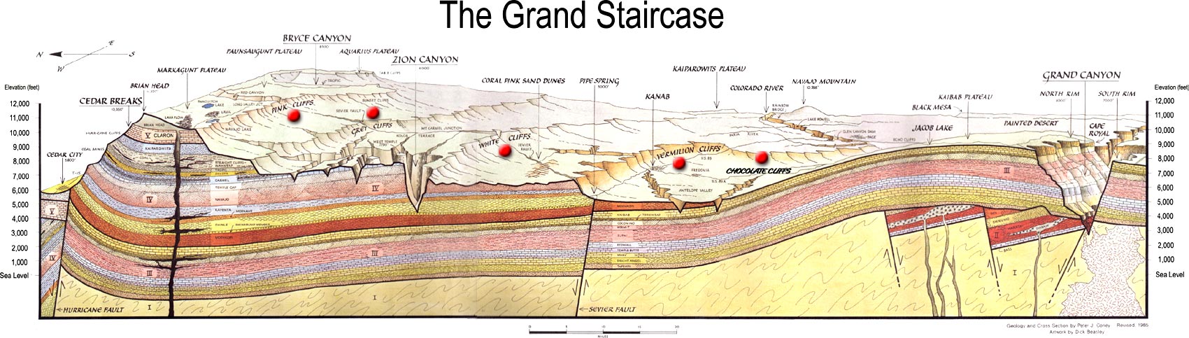
Between the Bryce and Grand Canyons is "The Grand Staircase," a series of cliffs named for the color of their rocks: Pink Cliffs, Gray Cliffs, White Cliffs, Vermillion Cliffs and Chocolate-Shinarump Cliffs.

Since there is little rainfall, there is little vegetation. Glorious rock formations dominate spectacular scenery.

Last year we recorded our trip with a digital camera. We are bringing that camera, but we are also bringing an easy-to-use Flip Ultra video camera. It is designed to record an hour of video and easily upload that video to YouTube. We plan to upload video to YouTube. Links in our blog will lead to our videos on YouTube.

Chris

Tuesday, November 27, 2007

Sunday, November 4, 2007

Day 14: Action Figure Museum, OK Bombing Memorial, Home

We will arrive home tonight.

Our first stop is the Action Figure Museum in Pauls Valley, Oklahoma. This is a collection of thousands of action figures with few explanations. This is the owner's collection on display, most still in the original packaging. Display of all the Batman figures required three large exhibits in a Bat Cave in the rear of the store. There were two hands-on play areas. One allowed visitors to try on various superhero costumes and admire themselves in a mirror.

The most amusing display was the collector's bedroom (shown below). The description at the front of the exhibit explained this was the bedroom of a collector who still lived at home (because who else could afford to buy every version of every action figure?), was overweight from eating cookies and lacked social skills.


Pictures of museum on Flickr.

Our next stop was the Oklahoma City National Memorial for the April 19, 1995 bombing of the Alfred P. Murrah Federal Building. This place has a memorial and a museum. The memorial is composed of several parts.

The street where the van exploded has been replaced by a long black granite reflecting pool. The bomb exploded at 9:02 am. At each end of the reflecting pool are tall black "gates" labeled 9:01 and 9:03 for the minutes before and after the explosion. The pool and panels capture the moment when the explosion changed us.

On the Federal building side of the street is a field of 168 empty chairs representing the children and adults who died in the explosion. The chairs are arranged in nine rows for the nine stories of the building.

In the picture below, the empty chairs are just outside the right side of picture. The camera is looking down the reflective pool toward gate 9:01. Behind the camera is gate 9:03.


Pictures of memorial on Flickr.

On the left side of the picture, the largest tree on the distant hill is the Survivor Tree, an American Elm that stood in the center of the parking lot across the street from the Federal building. The explosion badly damaged this tree. It lost all its leaves. After being heavily pruned, it sprouted growth and now symbolizes recovery from this tragedy.

To the left of the Survivor Tree is the Journal Record Building. The explosion heavily damaged this building. Three of its floors now house the memorial museum.

The museum begins by emphasizing how normal April 19, 1995 started. The explosion is represented by an actual tape recording of the beginning of Water Board hearing that began at 9 am on that day. Two minutes into the recording a loud explosion occurs. The explosion was so loud the tape was unable to capture its full resonance.

We then move into a room were we see the "live" newscasts immediately after the explosion. The rest of the exhibits document the experiences of the survivors, their families, the rescuers, the response of the public, the investigation and trial of the terrorists involved and world-wide media coverage up to the completion of the memorial itself. The coverage of these exhibits is very extensive and complete.

We arrived at home in Great Bend at around 9 pm Saturday night.

Day 13: History and Evolution

This morning we visited the Harold B. Simpson Complex and Research Center on the campus of Hill College in Hillsboro.

We went there so Kathy could check out its genealogical resources. It was originally called the Confederate Museum. The main display area exhibits paraphenalia about Texas Confederate regiments and explains Texas' unique role in the Civil War. Though Texans under Hood provided very reliable regiments for Lee's army, the state of Texas most important contribution to the war was supplying the Confederacy because Texas was the only Confederate state bordering a neutral country, Mexico. Mexico purchased southern cotton in exchange for important supplies. This important role ended when the Union completely controlled the Mississippi River with the capture of Vicksburg in 1863.
The museum now has exhibits about all major US wars including a fairly large collection of modern military weaponry. Not only rifles and machine guns, but also WWI hand grenades, bayonets and medieval-looking spiked maces and even a spiked-ball flail for hand-to-hand fighting.
In the afternoon, we looked at the 100 million year old dinosaur tracks in Dinosaur Valley State Park outside Glen Rose, Texas. Pictures on Flickr.
The tracks are in the limestone bottom of the very shallow Paluxy River which flows into the Brazos River. 100 million years ago this area was a beach on the ocean and several different types of dinosaurs vacationing on the beach left their footprints.
The nearby Creation Evidences Museum was closed by the time we got there. This museum is supposedly associated with Dr. Carl Baugh. Here is an older article with a picture of what it looks like today and an evolutionists critic of the museum's exhibits.
The Glen Rose dinosaur tracks were famous in the evolution-creation debate in the 1980s because the creationists claimed that some prints were actually human. Dinosaur and human prints appearing together would obviously disprove evolution.
We are camping in at Dave's campground west of Gainesville, Texas, a stone's throw from Oklahoma.

Day 12: Washington-on-the-Brazos and Barrington Farm

While Jim Bowie and Davy Crockett were dying at the Alamo, Sam Houston and 58 other Tejanos and Texans were busy declaring independence and writing a constitution at Washington-on-the-Brazos.

In 1836, Washington Town, as it was called then, was a new town being built near a river ferry crossing the Brazos. The town had only one street. Actually the street was logs cut low enough to allows wagons to allow wagons to roll over them. There were few houses and stores. The best building in town was still under construction shop being built by the Robinson who owned the ferry. A “blue northerner” had just arrived bringing freezing temperatures. Since the shop still did not have windows and doors or a stove, burlap what nailed over these openings keep out the cold wind.
One one ever mentions that the cold weather might have increased the efficiency of the meeting. However, the meeting opened on March 1 and the Texas Declaration of Independence was written and signed by March 2. Then then began writing the Constitution of the Republic of Texas.
When the Alamo fell on March 6th Santa Anna executed all the male fighters. This created a panic all across Texas called the Runaway Scrape. Delegates at Washington Town learned of the fall of the Alamo on March 15th. They assumed Santa Anna would come next to Washington Town. Nevertheless, delegates stayed until the Constitution was finished and the new administration was sworn in.
With the exception of the rebuilt Independence Hall, Washington-on-the-Brazos is now an empty field. The town grew until about the 1860s when the town leaders foolishly decided not to provide the $11,000 needed to bring the railroad through town. They thought the river would meet their transportation needs. So the railroad went to Navosota less than 10 miles away. In 1911, a fire swept through what remained of Washington-on-the-Brazos. Today, Navasota is a town and Washington-on-the-Brazos is a state park.

Washington Town, by the way, was named after Washington, Georgia, Robinson's hometown.

We also walked through the extensive museum of Texas history and Barrington Farm. Barrington farm is a living history farm of Anson Jones homestead. The cotton was still in bloom. Kathy is smelling a cotton flower.
Cotton varieties come in a rainbow of colors. White is most popular because it does not have to be bleached. This year Barrington Farm had brown and green varieties. The color fades after long exposure to sunlight.


The house is horizontally divided equally into three equal parts. At each end is an enclosed area divided into two rooms. One room in the front of the house. One room in the back of the house. The rooms at one end are the front and rear bedrooms. The rooms at the other end of the house are a dining room and parlor. There was a second story with three more rooms which were bedrooms for the kids. The middle third of the ground floor is a breezeway. This was a wonderfully cool place. There was a nice breeze. And we could easy see what was going on in the front and backyards. This was obviously a frequently used common area were the whole family would gather much of the time.
Anson Jones was president of the Republic of Texas when Texas was annexed to the United States in 1848. Anson Jones committed suicide 1858. Since he never left note explaining his reasons, everyone seems to have a hypothesis for why he did it. These range from morphine no longer eased the pain of his injured left arm to depression caused by failure at being elected to the US Senate to realization that he would not be able to start up his medical practice in Houston.

In this part of Texas chickens wear fancy hats.


The spiders jump on their lunch rather than use webs. There are 4,000 species of jumping spiders. This one holding a cricket is a Phidippus audax. Most spiders have eight eyes, but not necessarily good eye sight. Jumping spiders have four eyes in front and four on the top of their heads. These spiders seem to have especially keen vision.

In the past, when I have leaned over jumping spiders blocking their light, they turn their body so they can look up at me with their large front eyes.
When I put my finger down in front of them they will jump on it and then jump back. If I move my finger slowly toward them, they retreat. If I move my finger back, then they move forward and jump on and off it. Jumping spiders are the only insect I have been able to "play" with.

Day 11: On to Washington

While Travis, Crockett and Bowie were beating off the Mexicans at The Alamo, Sam Houston and 58 other Texans were declaring independence and writing a constitution at Washington-on-the-Brazos, a little ways north of Houston. So we left San Antonio heading east toward Washington.

We stopped at the Sebastopol State Historical Park in Seguin, Texas. This house is an early concrete house. The front room is large with windows and large doors on three sides. Very light and airy. The bedrooms in the back also open onto the large side porches. The kitchen is on the ground floor in the back of the house.
We camped at Navasota municipal park, near the airport. This costs $10. Since we did not have $10 in cash, we drove into Navasota to use an ATM machine. This was Halloween night. Kids literally lined the sidewalks waiting for candy.
During our drive to Navasota we passed lots of blacks in the country. East Texas was a cotton growing region with a numerous cotton planations before the Civil War. During the Civil War, slaveholders in other parts of the south sent their human property to Texas away from the Yankee invaders who freed slaves.

Day 10 Buckhorn and O. Henry's house

We rode the bus downtown again. This time we visited The Buckhorn Museum. The museum has a huge antler collection. The founder Frederick Buckhorn used to give cowboys a free beer if they brought in a horn. The museum also has an extensive collection of stuffed land animals and fish from around the world. And a Texas Ranger museum including a Bonnie and Clyde car covered with bullet hole decals.

About a mile away in O. Henry's two-room house. O. Henry worked as a bank teller and small-newspaper editor in San Antonio. When he was accused of embezzlement he ran to South America. He returned when his wife got sick, turned himself in and spent three years in jail where he learned to write short stories. Now the local sherrif's department supplies teenage caretakers for O. Henry's house so they too can improve themselves through punishment.
Near the O. Henry house is Market Square. We ate a Mexican lunch. During lunch an old guy with a guitar asked us if we wanted music. Chris foolishly approved and we had to suffer through a poorly sung Spanish song you have all heard, but I don't know its name. We overpaid his efforts with some change. He deserved a beating. OK. OK. He was an old guy. He can't help it if his voice is mostly shoot. He deserved retirement.
We walked around the Market Square. Lots of colorful clothes, pottery, posters, t-shirts, hats, etc. etc. etc. Mexican style. All-in-all the quality was higher than the usual tourist junk because much of it was intended for serious interior decoration and wearing.
That evening we drove around San Antonio. We were looking for a costume warehouse and an exotic meat market we had seen earlier. We did not find these stores, but we did shop in a very large Goodwill-type store. We bought a can opener, 2 pairs of shoes and an experimental statistics textbook.

Day 9: Relearning the Alamo

This morning we rode the bus downtown and got off several blocks from the Alamo. The Alamo was one of the five missions of San Antonio. The mission's original name was San Antonio de Valero Mission. After the San Antonio missions were closed by the Spanish government, Mexican government ordered the mission fortified by The Second Flying Company of Álamo de Parras in Mexico. The name Alamo honors these Mexican troops.

The roof and the curved top of the front of the Alamo church was added by the US Army in the 1840s. All the fighting took place outside this church. David Crocket's men defended a wooden stockade wall near the front of the church.

A guide described the events leading up to the Battle of the Alamo. (Flickr pictures of the Alamo.) Try as we might, they refused to show us Alamo's basement.

The Texas Revolution lasted from the Skirmish of Gonzolas on October 2, 1835 over a small cannon to the 18-minute Battle of Jacinto April 21, 1836.
Kathy found and purchased a really great looking t-shirt at a extremely good price at the gift shop. The shirt gray with an elegant "Remember the Alamo," March 6, 1830 on the front. When Chris wore it two days later, Kathy noticed that the year on the t-shirt is 1830. The Battle of the Alamo occurred in 1836.
After visiting the Alamo Kathy and Chris took a river walk boat cruise.

Day 8: A Sunday mission

Sunday, we drove to Sunday service in the church of Mission San José y San Miguel de Aguayo, one of five churches in the San Antonio Missions National Historical Park. (Flickr pictures)

The Catholic mass is enlivened with mariachi music. Kathy liked the upbeat happy music. The place was packed. At one point everyone in the rows held hands, even across the aisles, and we sang and rocked to the music. At the end of the service everyone celebrating birthdays and wedding anniversaries was invited to the front. A couple celebrating their anniversary danced to a mariachi waltz.

A chapel on the south side of the church has been set up for the Day of the Dead celebrations. On and around the alter people put pictures of dead relatives and stuff they liked: lots of favorite toys for children and soft drinks for adults. Other symbols include skulls with people names on them and hanging colorful paper cutout with symbolic designs.

After the service the mariachi band entertained worshipers in front of the church convent.


Kathy and Chris took a tour of the mission.
It is walled with gun ports covering the gates. The mission was established to Christianize and civilize (i.e., turn them into tax-paying Spaniards) the Coahuiltecan Indians. The missionaries, soldiers and visiting European dignitaries lived in the convent near the church on the right end of the above map. the indians lived in two-room houses in the rest of the walls.
The guide corrected our Western misinterpretation of a common Indian scene. An Indian couple are traveling together. The man is walking out front carrying his bow and arrow. The woman is walking behind dragging the household and with a baby in tow. Westerners wonder why the man doesn't help the woman. The guide said the man is carrying his stuff and is ready to take advantage of any prey that may cross their path or defend the woman and child. The woman is carrying her stuff. It's her stuff. She would not want a man to carry her stuff.
We camped at Traveler's World, a mile south of downtown. That afternoon drove downtown, walked the Riverwalk and to the Alamo.

Day 7: San Antonio at last

Chris began the morning with a tour of the rock art at Seminole Canyon State Park and Historic Site.
The tour begins with a walk down stairs to the bottom of the canyon, then along the bottom of the canyon to the rock art cave. This canyon is created by the run off from the surrounding land during rain storms. The water flows into the Pecos River a couple of miles down the canyon. The bottom of the canyon is dry except for large puddles of water here and there. The cave ahead has thousands of drawings over thousands of years. The ash on the floor we walk on is 12' to 30' deep. In the ash are layers of ancient woven mats that are like rugs so the people did not walk on the ash.

Many pictures easily seen because the colors permeated the porous rock. Most of the art is the Pecos River style. We don't know what the pictures actually mean. Most are human figures. Some have animal-like features such as deer antlers or wings. But they are not doing clearly identifiable actions like hunting. The current interpretations are that these pictures represent the spiritual trips to the underworld of shamans, but these are only guesses.
We drove onto San Antonio. Our campground was north of San Antonio, 10 miles south of New Braunfels. That evening we drove to New Braunfels. We first searched out the Schlitterbahn which is claimed to be the largest water park in North America. Actually there are three Schlitterbahn water parks. The other two are at South Padre Island and Galveston Island.
While driving through downtown we spotted a marquee on the BraunTex which said “The Three Redneck Tenors” would be performing that night. We immediately parked the van and walked to the box office. As luck would have it, we purchased the last tickets. They were balcony seats. We returned to the van, changed our clothes and returned to the theater for the gala performance.
One of the three redneck tenors wrote this corny opera and hired three other guys, one gal and a band to put it on around the country. They recently recorded a Christmas album and will be performing at the Luxor in Las Vegas in the coming month. They really are good singers, but their acting and show is rather corny. The storyline is that a Kentucky Colonel-type promoter discovers three redneck boys with lots of natural singing talent, but no class. Nevertheless, he is going to make them stars. The rest of the play consists of their various performances from local rodeos up to Carnegie Hall.
In each performance up the ladder to success they wear different costumes and sing a different type of popular songs including medlies of TV themes and patriotic songs, Elvis Presley numbers and old country favorites, stuff the greatest generation would recognize, nothing newer than probably 1970. Most songs are sung straight, but they do an interesting combination of Ave Maria and Dixie. Many songs can be heard on their MySpace page.

Day 6: Mexican vendors at Boquillas Canyon

We drove from Shady Butte back across Big Bend National Park to the east side and Boquillas Canyon.
On this side of the park there is an overlook where we can easily see the countryside surrounding Boquillas Del Carmen, Mexico on a distant hill. Just across the river we could see
several Mexicans working in a grove. One called to me, “Amigo, (Mexicans always call you amigo.) do you want to buy a walking stick?” It was easy to hear him despite the distance. I called back, “No.” A couple of minutes later a young Mexican man arrived at the top of the hill carrying a load of stuff to sell: four walking sticks painted with colorful drawings of cactus and
birds and the words Boquillas, Mexico, several scropions made from twisted red wire, some arrowheads and a jar for money. A badly worded sign that said scorpions cost $5 and the money was for a charity for kids.
Chris purchased one of the red wire scorpions with red eyes. We are going to hang it from the mirror in the van.
Chris then hiked up Boquillas Canyon. This canyon is more open than Sana Elena Canyon. The ground is sandy and more open. During the walk in I came across two more offerings of walking sticks, wire scorpions and purple agates of various sizes. The scorpions in one offering were vary large and cost $7. The price of agates ranged from $5 to $20. The sellers were sitting on the other side of the river were they could see their wares. One guy was sitting in front of a 10' by 10' hut made of reeds (very center of the picture). He called across to me and asked if I wanted to buy anything. Again I said no. He sang a song as I walked out of the canyon. His voice was not beautiful, but it was loud. He sang in Spanish. I did not recognize the song, but one lady I passed said in a Spanish accent that she recognized the song.

After the canyon we drove north back to Marathon and then east toward San Antonio. Just before the Pecos River we stopped at Langtry, where Justice of the Peace Roy Bean ran a saloon where he provided the “Law West of the Pecos.” Judge Bean has a reputation of being a hanging judge. Though he often threatened to hang men, he only condemned two men to die. At least one escaped. Bean was in reality a con man who bilked customers out of money during court and known braggart with a flare for self-promotion.
Roy named his saloon the Jersey Lily after Lilly Langtry a famous British-American actress of the day. He wrote her letters and often bragged that she someday she would arrive on the train for a visit. On the evening of March 15, 1904, Roy Bean got drunk and died the next day. Ten days later Lilly Langtry actually did show up at Roy Bean's bar and courthouse. Roy's regulars told her stories about him. Like the time he fined a man who had committed suicide. The guy jumped off a bridge and died. In his pocket was a pistol and $40 in gold pieces. Bean fined the man $40 for carrying a concealed weapon.
We camped down the road at Seminole Canyon State Historical Park. This large canyon is not a river canyon. It has been created from the run-off of rain flowing toward the Pecos River. The smooth bottom of the canyon is dry accept for some small pools of clear water. However, this canyon is a state park because the sheltering overhangs cut into the canyon sides are covered in rock art several thousand years old.